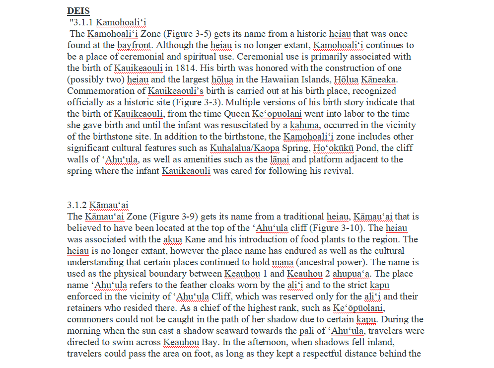
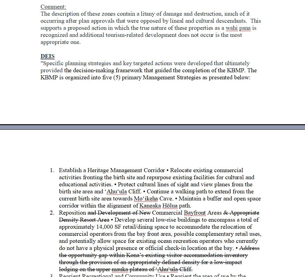
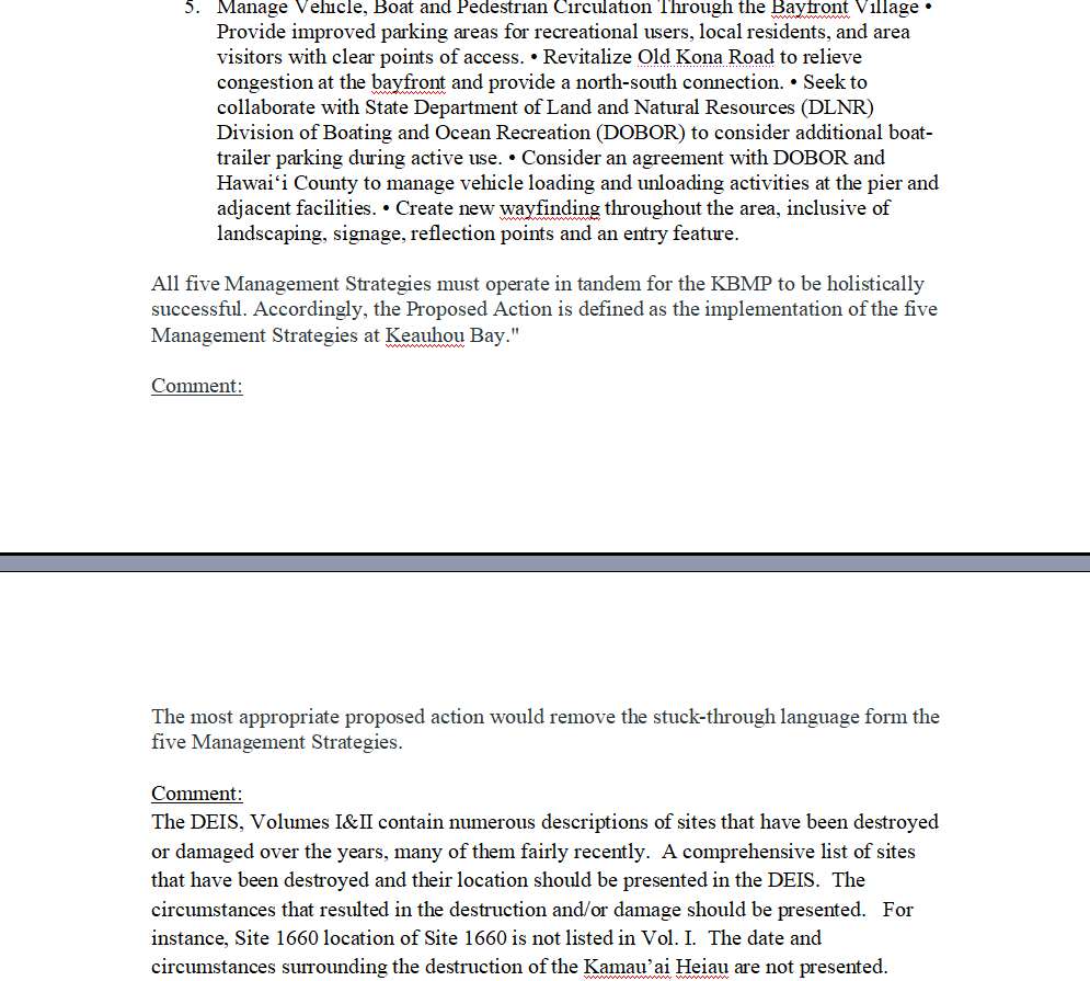
eis comment letters to save keauhou bay
Lawyers, Hawaiians, Scientists and the Sierra Club's Opposing EIS Comment Letters to HELP SAVE Keauhou Bay From Kamehameha Schools EIS Draft to Develop a Big Bungalow Resort
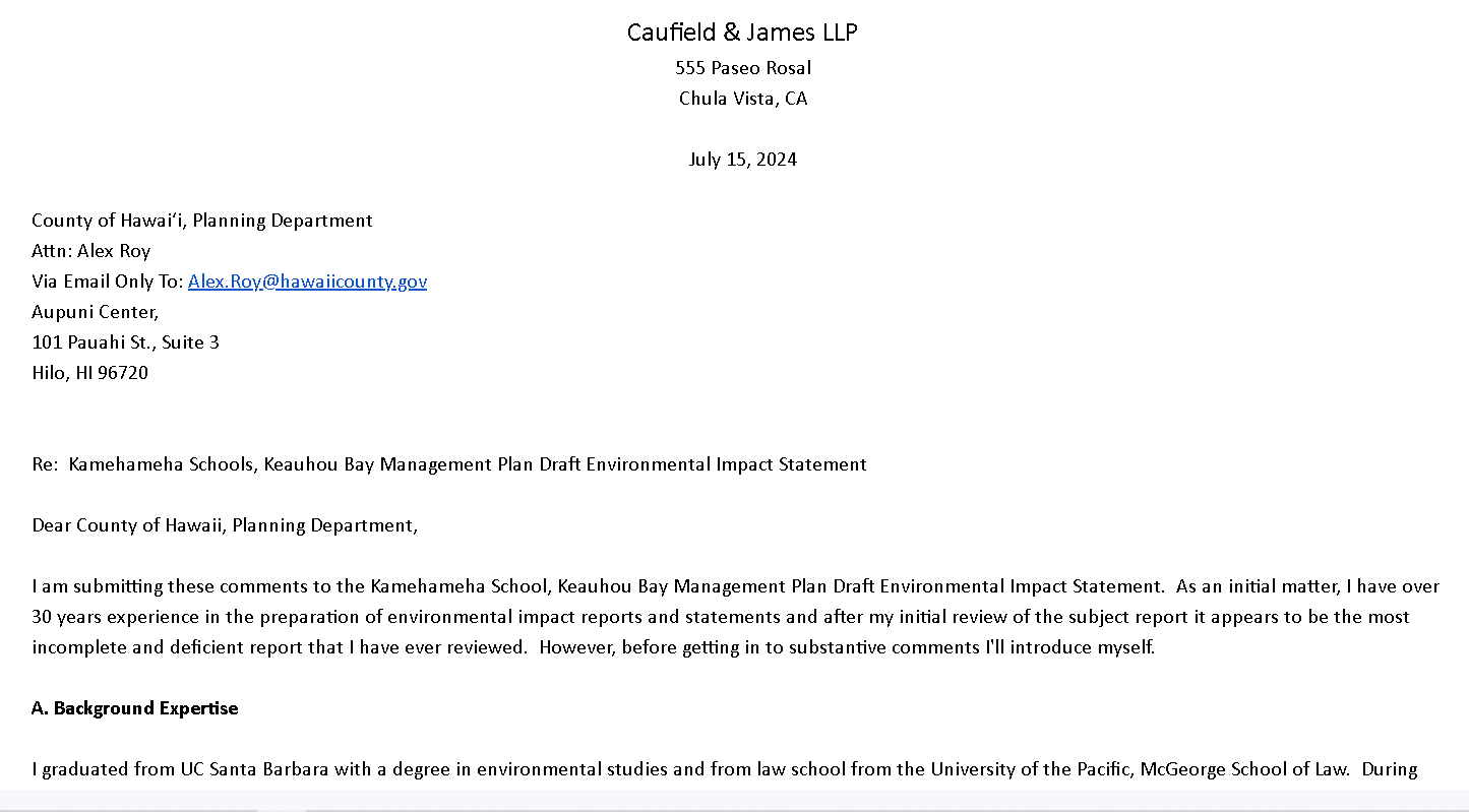
Caufield & James LLP
Environmental Lawyer
July 15, 2024
Re: Kamehameha Schools, Keauhou Bay Management Plan Draft Environmental Impact Statement
Dear County of Hawaii, Planning Department,
I am submitting these comments to the Kamehameha School, Keauhou Bay Management Plan Draft Environmental Impact Statement. As an initial matter, I have over 30 years experience in the preparation of environmental impact reports and statements and after my initial review of the subject report it appears to be the most incomplete and deficient report that I have ever reviewed. However, before getting in to substantive comments I'll introduce myself.
A. Background Expertise
I graduated from UC Santa Barbara with a degree in environmental studies and from law school from the University of the Pacific, McGeorge School of Law. During undergraduate studies I worked at the Institute of Crustal Studies Vadose Monitoring Laboratory conducting cutting edge research in the movement of pollutants within the vadose zone (defined as the zone of soil between the surface of the earth and groundwater.) Prior to becoming an environmental attorney, I worked for several years as an environmental consultant. I also previously clerked for the United States Department of Interior, Regional Solicitors' Office and the California Department of Fish and Game, Legal Advisors' office. For the past 31 years my legal practice has been in environmental law where I have litigated dozens of cases on behalf of and against public entities related to Environmental Impact Reports and Environmental Impact Statements. I also have assisted in the preparation of many environmental impact assessments, including providing substantive comments and review on behalf of multiple public entities and a number of cities. Part of my expertise includes analyzing traffic impacts, runoff issues, noise impacts, air impacts and toxic/nutrient loading impacts from projects. I have spent literally thousands of hours over the last 30 plus years analyzing such impacts. To date, I have never lost of single case involving litigation over the sufficiency of an Environmental Impact Report or Statement. I have been considered by several courts to be an expert in environmental impact reports and litigation. In one of the last cases I handled involving the failure to prepare an appropriate EIR, the Court awarded over $400,000 in attorneys' fees and costs to my client as the prevailing party. That amount could have been avoided had Los Angeles County simply listened to the comments that we provided. Accordingly, we urge you to similarly listen to our comments as the failure to do so may result in a large and expensive piece of litigation. The environmental impact report and statement litigations have involved a number of subjects including impacts to the local coastal zone and waters. Additionally, I have litigated dozens of cases involving toxic substances, including damages caused to water bodies from excess nutrients and toxic substances. I am on the editorial board of the Environmental Forensics Journal. I am routinely invited to lecture both nationally and internationally on issues involving the detection and impact of toxic substances and nutrients on the environment, including coastal waters. For example, I was asked to speak at the International Environmental Forensics Conference in China where I spoke on the admissibility of expert opinions in environmental forensic cases related to toxic pollutants. I also have been published in a number of books, publications and have been interviewed numerous times as an environmental expert by local and national media. I also have been a frequent user of Keauhou Bay for over 20 years such that a number of my comments are based on my personal observations over the course of several thousand hours over the last 20+ years. For the past two years I have spent over 200 hours observing usage of the bay, including public usage, the boat ramp and commercial/tourist usage of the bay particularly related to some of the initial scoping documents to see if there was any veracity in the claims presented by the Project proponent.
B. Substantive Comments
As discussed supra, the subject EIS is facially deficient and must be rejected in its entirety. Under existing law, the EIS conclusions and analysis must be supported by substantial evidence to support the analysis and conclusions. It is the burden of the party preparing the EIS to provide support for the document. The failure to provide the required supporting evidence for the statements and conclusions requires that the document be rejected by the reviewing public agencies. For the most part, the EIS appears to be a series of unsupported statements and conclusions and written to appear more as an advertising document for the project intended to "sell" the project to both the public and regulatory agencies rather than providing any substantive research and/or analysis. The comments listed below are not necessarily all inclusive but highlight the many deficiencies. It is our understanding that a number of other experts will also be submitting comments highlighting the deficiencies in the EIS and those comments are referenced, adopted and should be considered to be included herein.
1. The Project Provides No Support Of How It Will Alleviate "Congestion" Use Conflicts
First, the EIS creates a straw man argument that Keauhou Bay suffers from "congestion" and conflicts with incompatible uses. There is no supporting study analyzing the existing number of users on a daily, weekly, monthly and/or annual basis nor the type and timing of the usage. Without such an analysis, the statement that there is a problem with "congestion" and/or "incompatible uses" is simply unsupported by any evidence. There are one or two photographs depicting people standing around the publicly owned dock area, which as people are congregating in publicly owned spaces the report fails to explain how the Project will prevent the public from congregating on publicly owned land. There is also Figure 3-13 which depicts a picture of the bay with ZERO people present, which directly contradicts any claim of congestion. Other than reducing access to publicly owned space, the project provides
no analysis
of how it will reduce the existing number of users nor the purported "incompatible" uses. Without underlying research, study and analysis the statements that the project would reduce "congestion" and/or use conflicts is unsupported and the EIS must be rejected on this basis alone. In fact, it would be reasonable to conclude that the project would substantially increase congestion and use conflicts at Keauhou Bay. For example, with the construction of 43 housing structures containing 150 housing units, which will each likely have 2 cars, with a minimum average of 4 car trips per vehicle per day, the housing units alone will likely add OVER 600 vehicles trips per day. (Based on my observations, the housing units alone will more than likely, on their own, double or triple the amount of traffic in the area.) Plus, you are adding hundreds of new visitors staying in the new housing on the bay, which presumably those new visitors will visit and use the bay. With the proposed cultural center, commercial center, commercial kiosks and employees/workers at the new proposed resort, there obviously will be a substantial increase in the number of additional vehicle trips per day. I'd note that the nearby Puʻuhonua o Hōnaunau National Historical Park ("City of Refuge") reports over 300,000 visitors per year to the site and cultural center. (Volcanoes National Park attracts over a million visitors per year.) Will the new proposed cultural center (located substantially closer to the City of Kailua-Kona so it will be much easier for visitors to access) attract a comparable number of visitors per year to the City of Refuge? The EIS provides no projections based on increased numbers from the cultural center. Even assuming the new cultural center only attracts 100,000 visitors per year (which is less than 33% the number that visit the City of Refuge), that equates to nearly 30,000 additional vehicles trips alone per year. (Note: the City of Refuge Parking lot has 75 parking spots plus there are usually 20 plus cars parked outside the gate, meaning that with staff there are 100 plus parking spots associated with the City of Refuge that are frequently full. The Project proponent has ZERO parking spots in the EIS for the "cultural center" beyond the existing parking.) The kiosks at Alii Marketplace have approximately 40 parking spots that are largely full most of the time. Accordingly, one would anticipate the "kiosks" at the Project will require comparable parking (if not more because kayak and SUP rentals are likely going to stay longer than visitors to Alii Marketplace.) Accordingly, it may be reasonable to conclude that the Project will add a demand for upwards of 140 parking spots to the existing parking demands. There is no study of the existing parking requirements not assessment of the future parking requirements should the project be implemented. Plus, the EIS identifies the launch ramp area as the area of purported greatest congestion and yet the project proposes to ADD substantial numbers of visitors and vehicles to the area of alleged greatest congestion. The launch ramp cue (i.e. Vehicles/trailers waiting to launch and/or pull-out boats) is noted as an area of greatest congestion. The cultural center is proposed to be built in the area of greatest congestion. The Project fails to explain how adding thousands (if not tens of thousands) of more people and vehicles to the area identified as having the greatest congestion will be reduced by the Project. Particularly, the EIS fails to contain projections as to the increase in number of visitors and vehicles to the area and the extent to which the Project will impact those levels. (Note: With 43 houses and 150 units being built on the bay likely housing 250+ tourists each day plus commercial kiosks with kayak and SUP rentals, the bay daily usage will also likely substantially increase and yet there is no estimate of that impact.) There is NO analysis of the impact on local flora and fauna from the likely increase usage of the bay arising from the project. Moreover, with the addition of SUP and kayak rentals on the bay, the Project is likely to increase conflicts with the existing boating usage of the bay for ingress and egress to the loading ramp and dock area. There is no analysis of the future impacts on existing uses of the bay with the addition of rental kayaks and SUP to the bay. For the foregoing reasons, the EIS must be rejected for failing to provide supporting evidence and documentation.
2. The Report Fails To Analyze Traffic Impacts
As discussed supra, the Project proposes to build a resort with 43 housing structures with 150 housing units (Note: the term "bungalow" seems to be an attempt to mislead the public in to believing that what is being proposed are not in fact large multi-bedroom homes), commercial kiosks, cultural center and commercial/retail center. It also proposes to build a new road connecting the north and south ends of the bay. As discussed supra, the Project will likely result in a minimum of hundreds, if not thousands, of additional vehicle trips per day. There is no study of the what the current number of vehicle trips per day are on the surrounding public roads, the level of impact of the existing stop lights nor the number of vehicles that travel from the south-north and/or north-south on the existing roadways that would conceivably use the new road. Accordingly, there is no evidence of what, if any, the amount of reduction on the existing roadways would be by the construction of a new road. Moreover, there is no analysis of the additional vehicle trips that would be created by the Project and what those impacts would be on existing traffic conditions nor existing parking. (Note: the impact of toxics on the bay from the Project will be discussed separately.) Moreover, the EIS fails to address how the Project proposes to mitigate the increased traffic impacts. Finally, the EIS asserts that the Project will reduce traffic impacts, without the citation to any evidence and/or study supporting that conclusion. The project also proposes to relocate the existing commercial snorkel boat vendors to the other side of the launch ramp, which means the snorkelers will have to walk across the purportedly congested boat ramp to get to the dock area and load on the snorkel boats. (Note: With the current buildings next to the dock, the snorkel visitors don't have to walk across the busy double-lane boat launch ramp. (One can just imagine how many people will get run over by people either trying to launch and/or pull boats from the water during the day and at night.) On this basis alone, the EIS must be rejected and further studies conducted.
3. The EIS Fails To Address Noise Impacts From The Project
The Project purports to build a large resort, commercial center, cultural center and commercial kiosks. The majority of the project will tear out historically forested areas for which the only noise being generated is by natural flora and fauna and replace it with a resort and new road. There is NO study of the existing noise levels in the area. There is NO analysis of what increased noise impacts to the area will be from the Project other than conclusory statements that are without supporting evidence and/or study. Obviously, the Project will materially change existing conditions related to noise through a substantial increase in activity around the bay. (Potentially adding thousands of new visitors and vehicle noise to the bay area on a daily basis.) An noise study must be conducted to analyze existing noise levels and potential future noise levels.
4. The EIS Fails To Address Air Impacts From The Project
The Project proposes to build a large resort, commercial center, cultural center and commercial kiosks. In building the project roughly 20+ acres of existing native forest will be destroyed to build the resort. As discussed supra, potentially thousands of additional vehicle trips will be added to the area without any analysis as to what the existing air quality conditions are nor the impact of the additional vehicular and project features are to the local air quality. For example, even if the cultural center only has a fraction of the visitation as the 300,000 plus visitors that visit the City of Refuge, that could generate tens of thousands of additional vehicle trips to the bay area on a yearly basis and have potential consequences to the local air quality. (Note: The area is generally not served by any public transportation, which necessitates vehicular travel.) A study needs to be conducted as to existing air quality and future projected air quality impacts from the project, including destruction of forest.
5. The Report Fails To Address Historical Runoff Issues
Currently, Kamehameha III Drive experiences flooding after even an average rainstorm. (Personal observations over the last 20 years.) Portions of the flooding appears to originate from Project lands and nothing in the EIS addresses how the Project will address existing flooding on Kamehameha III Drive caused by Project lands. The EIS also fails to address the fact that historically there were two sand volleyball courts. The 2
nd
court was situated in the publicly owned land between the seawall and the existing volleyball court. When the project proponent cleared lands (it appears illegally and without and EIS and/or other permit) to construct the existing parking lot and boat storage area the drainage was substantially effected and the rather than have vegetation slow the water flow, the surface flow rate dramatically increased and the 2
nd
sand volleyball court was washed out along with portions of the remaining volleyball court. (Personal observation.) Note: The EIS fails to address the permit status of the existing boat storage and parking lots on the northern side of Keauhou Bay and I could not find any permit with the County for the construction nor corresponding environmental documentation. Accordingly, it appears that the boat parking lot and other parking lot may be unpermitted. The Project proponent failed to make repairs to the 2
nd
sand volleyball court located on public lands and existing sand volleyball court that its apparently illegal development destroyed. The EIS fails to address the apparent illegal development of the current northern parking lot and boat storage lot nor the environmental impacts therefrom. Notably, the EIS fails to also address that to the North of the sand volleyball court is a historical catchment area that helped capture runoff from the northern area where the new parking lots and boat storage were added. (Personal observation and interview of locals.) The Project proponent has failed to maintain the catchment, which has contributed to excess runoff from the area that has damaged publicly owned property. In interview of locals, in the past there have been attempts by the locals to keep the catchment clear so as to reduce flooding from the upper areas. The EIS must address the permit status (or lack thereof) of the apparently illegally constructed parking and boat parking lots including the lack of environmental review thereof, the historical runoff issues from the Project proponent lands that have caused damage to publicly owned property and how the project will mitigate existing issues. For this basis alone, the EIS must be rejected and further studies and assessments conducted.
6. The Project Fails To Address Additional Runoff Impacts From Increased Hardscape
The project proposes to take existing native vegetation areas and tear them out in favor of building the resort, commercial kiosks and commercial/retail. Based on the review of project maps, it appears that roughly 15-20 acres of native vegetation will be removed and replaced with mostly hardscape. There is NO analysis of the existing runoff from the "as is" condition of the properties and project area. There is also no study/analysis and/or projection of the increase flow and rate of runoff from the increased hardscape. The potential increased flow has the potential to alter the fresh/saltwater balance within the eastern end of the bay, which could impact fish and coral. This is a requirement of the EIS. The failure to include such an analysis mandates that the EIS be rejected and further studies of historical, existing and potential future conditions analyzed with appropriate mitigation measures.
7. The Project Fails To Study, Analyze And/Or Provide Projection As To Increased Toxicity And Eutrophication Impacts To Keauhou Bay
As discussed supra, the Project proposes to add potentially thousands of new vehicle trips to the area surrounding Keauhou Bay every day. Also, the Project proposes to add a new road closer to the Bay that would carry the additional traffic along with re-routing existing traffic that is currently roughly more than a ½ mile away and that currently drains to an existing golf course and forest area. Roadways are well known for the ability to accumulate and dispense toxic pollutants during rainfall events. Thus, by positioning the roadway closer to the bay there is the potential for an increase in toxic pollutants entering the bay and impacting existing flora and fauna. There is NO study and/or analysis of the existing toxicity of runoff to the bay from nearby roadways. Additionally, there is NO analysis or projection of the concentration and ecological impact of the project and additional roadway on future runoff to the bay arising from the Project. Not only do roadways accumulate toxicants that runoff the roadways during rainfall events, but projects such as resorts with houses, pools, lawns etc... also have increased runoff of nitrates and phosphates. Nitrates and phosphates, among similar chemicals, are well known to cause eutrophication to water bodies. Golf courses also have the potential to release substantial amounts of nitrates and phosphates through runoff. Currently, the golf course to the east of the bay drains into the forest area, which the Project proposes to remove. The forest area likely acts as buffer that absorbs nitrates and phosphates that are captured by the existing forest area. At times, after heavy rainfall, the end of the bay closest to Project proponent's property can appear slightly green and with surface scum, which suggests that under current conditions there may be nutrient issues with the current runoff. Not only does the EIS fail to analyze existing conditions but also the impact of the removal of the forest, construction of the road and construction of the resort on the future release of eutrophic chemicals to the bay. On this basis alone, the EIS must be rejected and further study conducted.
8. The EIS Fails To Take In To Consideration The Historical Failure Of Proponent To Maintain Existing Facilities
The EIS fails to analyze the long history of the failure of the Project proponent to provide maintenance to the existing properties. The EIS vaguely references the long-term maintenance issues related to Project proponent's properties and then suggests that the maintenance failure is due to the lack of income from the properties and that in the future the maintenance will improve. Such a suggestion by Project proponent is misleading at best and verges on being an outright fraudulent misrepresentation. Project proponent is a $14.6 billion dollar entity according to its website. (See
) Thus, the suggestion that the lack of maintenance was due to the lack of funds is outright untrue as the Project proponent for all intents and purposes has an unlimited amount of funding available in which to conduct maintenance. Moreover, Project proponent has historically received funding from the Keauhou properties through the boat yard rental, parking, canoe club and building rentals such that the failure to conduct maintenance is inexcusable. For example, the existing seawall owned by Project proponent has been in serious disrepair for over a decade, with the wall having large pieces falling off into the ocean and no repairs have been made. Similarly, after Project proponent's construction of the apparently unpermitted northern parking lots occurred and the sand volleyball court built on public lands was washed away, Project proponent failed to attempt to any repair. Project proponent failed to maintain existing drainage structures to the north of the existing volleyball court. Moreover, the cultural heritage corridor (which they supposedly they care about) has been allowed to fail into disrepair, with broken benches for sitting, peeling paint, overgrown plants and trash that have largely gone unrepaired and neglected for the last decade or more. (Personal observation.) Thus, there is ZERO evidence to support that if the Project is approved that the Project proponent will suddenly and magically start to actually do maintenance on its' properties. As a result, the EIS MUST consider that the Project proponent will act EXACTLY as it has in the past and continue to fail to maintain its' properties and what the implications will be on the future for the Project based on the last many decades of neglect by the Project proponent. Moreover, the EIS fails to disclose and discuss the long history of scandal and abuse associated with Project proponents organization and what transparency will exist to ensure that the Project will do what it is supposed to do. (See e.g.
) The EIS mentions nothing of other "projects" such as the cultural center and botanical gardens along Alii Drive that Project proponent has abandoned and failed to maintain in the past and currently. There is NOTHING in the EIS that provides any checks and balances to ensure that the Project will actually be maintained and based on history on the Project properties and nearby failed projects by the Project proponent, it is unlikely that the Project will meet its' promises. Moreover, the EIS, based on the poor maintenance history by the Project proponent on these and other nearby properties needs to consider the impacts of the Project proponent continuing to conduct basic maintenance on the Project properties as it has done for decades. In other words, the EIS needs to address not only the lack of historical maintenance, other failed nearby projects, and the impact of the failure to maintain the Project in the future. (Typically, a Project such as this will have a detailed maintenance and upkeep schedule of the Project and mitigation measures that then can be adopted as conditions of the Project approval and be enforceable by regulatory agencies.)
9. The Project Blocks Public Access Across Publicly Owned Property
Based on the maps attached to the EIS, there is publicly owned property extending from the end of Kamehameha III Drive to the boat dock area. Currently, there is a path that extends from the end of Kamehameha III Drive to the boat dock area that allows access to the boat dock area. (personal observation and use.) However, the project proposal maps appear to block to existing publicly owned path from the end of Kamehameha III Drive to the dock area. Project proponent misleading fails to identify the existing path and access across publicly owned property. Nevertheless, the Project proponent proposes to block access to the public across publicly owned property, which is illegal. As a result, the EIS must be rejected and the current public access preserved in future versions should be Project wish to move forward.
10. Destruction Of The Sand Volleyball Courts Violates Proponents Charter As Well As Access To Publicly Owned Property
Historically, there were two sand volleyball courts located on the east end of Keauhou Bay. One of the sand volleyball courts was located at the western edge of Project proponents' property, which is the existing volleyball court. According to locals, the existing volleyball court has been in continuous use by the public, including locals and in particular local kids for at least 35+ years. Dozens of comments have been submitted stressing the importance of the sand volleyball courts to the local community. With the limited number of sand volleyball courts available locally, this is the primary sand volleyball court used by local kids who want to learn how to play sand volleyball. As women's sand volleyball is now a collegiate sport and men's sand volleyball is also poised to become a men's collegiate sport, the existing volleyball court is a critical resource for local kids hoping to not only learn how to play volleyball, but also pursue potential college scholarship opportunities. Notably, sand volleyball is one of the sports that most represented by local Hawaiians in the Olympics. Up until Project proponent cleared land to create the northern parking lot and boat parking, there was second sand volleyball court that was similarly used by locals. Project proponent proposes to eliminate BOTH volleyball courts and instead grass in the area as "open space." There is no analysis as to the impact of eliminating the existing volleyball court nor the impact on the local community and uses. Currently, there is roughly 10-20+ adults and kids that utilize the existing volleyball court on a daily basis. Accordingly, Project proponent should be required to analyze the impact of eliminating the existing volleyball court. There is nothing in the Project that would replace the 2
nd
court that was damaged by the excess runoff caused by land prior land clearing activities. At a minimum, the Project should be required to replace the 2
nd
volleyball court that was damaged by Project proponent's activities and to ensure that future runoff is controlled so it does not impact the sand volleyball court. Notably, historical photographs (See attached historical photograph from 1890) show that the East end of Keauhou Bay was a sandy beach ALL of the way up to the base of the hill to the East of the existing volleyball court. The seawall appears to be a late addition built within the existing high tide area. (See historical nautical chart dated 1949, which does not note the presence of any seawall.) Based on the 1949 chart, the seawall itself appears to have been constructed below the mean high tide line, which appears to be publicly owned land. Thus, a large grassy area constructed on Project proponents' property and on the publicly owned lands is incompatible with both historical and current uses. There is no analysis of the impact of the removal on historic cultural uses and current uses. To be consistent with historical uses on both the public lands and lands within the historical mean high tide, Project proponent should be required replace the sand that has been lost and to ensure that it cannot be washed away by excess runoff. Due to the failure to analyze the impacts of the sand volleyball court removal, proposed construction on publicly owned lands and within the mean high tide and the failure to consider future impacts, the EIS should be rejected. (Not to mention the failure to address seawall that is falling down.) Moreover, if Project proponent should consider moving forward in the future, the sand volleyball courts should both be replaced, the drainage fixed and maintained by Project proponent. All of the above should be supported by adequate usage and projection studies.
11. The EIS Fails To Address Congestion Caused Elsewhere By The Removal Of The Sand Volleyball Courts
It is my understanding that literally dozens of comments have been received outlining the usage of the volleyball court and negative impact from its removal. The remaining court is utilized on a daily basis by the public and local kids. It is a long-standing tradition that family's barbeque locally and play on the volleyball courts every weekend. With the removal of the remaining court, the usage will be transferred to already congested sand courts at Magic Sands Beach and Coconut Grove creating both congestion and usage conflicts elsewhere. The EIS fails to analyze existing usage nor where the existing usage would be relocated. It fails to address potential congestion caused at the other locations by the court removal. A study needs to be conducted of existing usage and the impact of shifting that usage to the 2 remaining sand volleyball courts in the area.
12. Existing And Future Impacts On The Coral In The Bay Are Ignored
The USEPA considers sedimentation, pollutants and nutrients to be some of the primary threats to coral communities. (
) A healthy coral community is key to maintain a healthy aquatic environment. The status of the health of the coral reefs within Keauhou Bay and the impact of existing sedimentation, toxics and nutrients has not been assessed. Current impacts from Project proponent's properties to the health of the coral reefs has not been studied nor assessed. The EIS fails to quantify the potential amount of sediment, pollutants and nutrients that may be generated from its construction activities nor from the Project. The EIS analyzes no potential mitigation measures that may be adopted to address past and current impacts to the bay from Project proponent's properties nor future impacts to the bay from the Project. As a result, the EIS is facially deficient and rejected so that the appropriate studies of the baseline conditions of the bay are studied and future project impacts are assessed and appropriate mitigation measures adopted to ensure the health of Keauhou Bay.
13. The EIS Fails To Consider Tsunami Impacts On The Cultural Center
Presumably, the proposed "Cultural Center" would contain hawaiian artifacts etc... However, the buildings that Project proponent proposes to utilize as a "Cultural Center" were badly damaged during the last tsunami (which was a relatively small tsunami.) If the Culture Center had been in operation during the last tsunami, precious artifacts would have been lost and/or destroyed. Instead, as the buildings housed snorkel tour businesses, all that was damaged was the buildings and their easy to replace contents. It is inconceivable that any entity that purports to be charged with a duty to protect cultural heritage would place a Culture Center at one of the highest at risk locations on the islands. (Due to Keauhou Bay's triangular shape and rapidly rising depths, a tsunami wave from a westerly direction is channeled, funneled and magnified by the shape of the bay.) This makes Keauhou Bay one of the locations on the western side of the island most likely to experience the largest tsunami impacts. The report fails to mention that entire buildings adjacent to the proposed Culture Center were destroyed by the last tsunami nor are any mitigation measures proposed. Without any information in the EIS it is unclear what if any protection would exist for the Cultural Center and any artifacts inside.

Threats to Coral Reefs | US EPA
Coral reefs are among the most biologically diverse and valuable ecosystems on Earth. This web site describes the importance of coral reefs, threats to them, and ongoing efforts to protect them.
14. The EIS Report Fails To Address Adequate Project Alternatives
The EIS and the Project proponent infer that there is a "need" for greater economic development and use of the property. However, the EIS fails to disclosure the current income levels from the current uses of the properties. Moreover, the EIS fails to address any "smaller" project alternatives. As everyone is aware, Project proponent has spent over a decade in construction of the Kahalu'u Ma Kai Project located on 22 acres nearby. (The hotel closed in 2012.) As that project historically operated a resort and was fully developed, logic would dictate that if Project proponent was concerned about income that property would an ideal location for a
resort. Currently, there is apparently no economic use being made of the Kahalu'u Ma Ka property and very little use for educational purposes. According to the locals, the primary use appears to be for private barbeques and events for select locals connected to Project proponent. (Notably, there seems to be very little to anything "cultural" about 22 acres of non-native mowed bermuda grass, which is a post-european contact non-native species.) Accordingly, if the income from the Keauhou properties is such a great concern, where they are currently making money, and Kahalu'u Ma Kai is making zero income, shouldn't the project be built on Kahalu'u Ma Kai and a more limited project build at Keauhou? The EIS does NOT explore that alternative. Moreover, across the street from Kahalu'u Ma Kai is, from my understanding, a former "cultural center" and botanical garden that was closed by Project proponent and appears to generate zero income. The EIS fails to analyze a situation where the resort would be constructed on that property and a smaller project constructed on the Keauhou properties. Again, the EIS should consider reasonable alternatives where Project proponents use underutilized properties near the Keauhou properties, and a smaller project be built on the Keauhou properties.
Conclusion
It would be hard to find a more defective and deficient EIS. In the last 30+ years I've yet to see a more facially defective and deficient EIS. The EIS reads like an advertising brochure with a bunch of unsupported claims and conclusory statements. The EIS appears to be written with the goal of misleading the public and regulatory agencies rather than informing them of potential impacts and setting out appropriate mitigation measures. There were virtually no studies conducted of the existing environmental conditions at, near and/or inside Keauhou Bay. Most of the summary conclusory statements have zero evidentiary support. In fact, most statements related to project impacts appear by use of simply common sense to be likely untrue, misleading and false. The Project proponent has the burden to conduct adequate studies of existing conditions and provide an assessment of future conditions, which is has failed to even remotely attempt to do so. The EIS should also assess mitigation measures to reduce the project impacts, which can then be adopted as conditions to the Project approval. Thus, if the mitigation measures and maintenance requirements be adopted as conditions of approval, they become enforceable by the County. The County of Hawaii legally cannot "weigh" expert opinion in deciding whether to approve an EIS. As there are no studies to support the conclusions in the report and multiple expert opinions pointing out the deficiencies in the lack of appropriate studies, projections and mitigation measures the County cannot legally approve of the EIS as drafted.
Very truly yours,
Jeffery L. Caufield
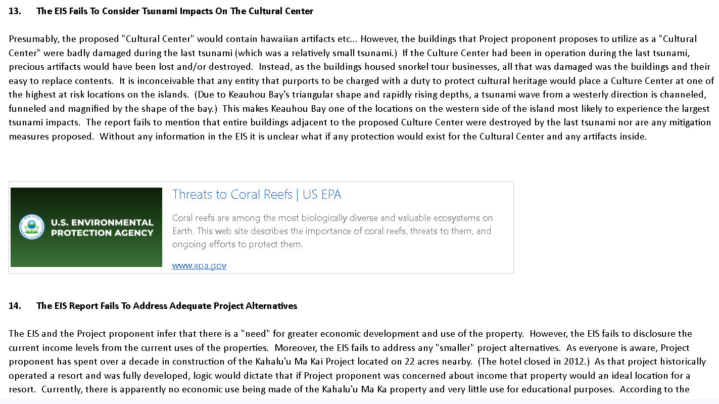
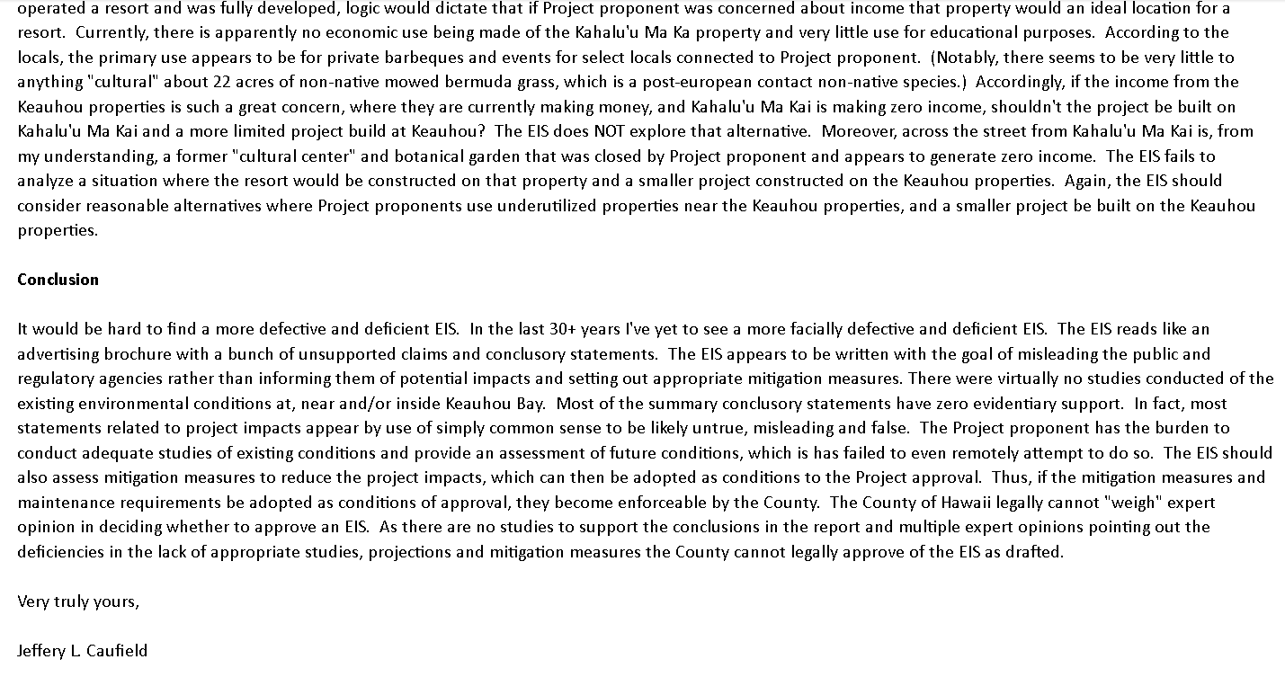
Photos of the actual letter he sent.
Department of Land and Natural Resources
Hawaii State Aha Moku
State of Hawaii
Post Offlce Box 621
Honolulu, Hawaii 96809
Aloha:
My name is Charles Young. I reside in the Ahupua`a of Kealia 11 South Kona. As the current Po`o of the
Hawaii Island `Aha Moku I am pleased to submit the following comments on the Kamehameha Schools,
Keauhou Bay Management Plan Draft Environmental Impact Statement.
The `Aha Moku was created by the Hawaii State Legislature under act 288, which recognized that
Hawaii has suffered through extensive changes to the Native Hawaiian Culture, Language, Values and
Land Tenure system resulting in the following
o Overrdevelopment of coastlines
o Alterations of freshwater streams
o Destruction of watersheds
o Decimation of coral reefs
o The decline of endemic marine and terrestrial species
The `Aha Moku serves in an advisory capacity to the Chairperson of the Hawaii State Department of
Land and Natural Resources (DLNR) so regional concerns from individual communities can be brought
to the DLNR and issues can be addressed and if needed, mitigated. In serving their individual
communities the Island `Aha Moku seek to
• Integrate indigenous resource management practices with western management.
• Identify a comprehensive set of indigenous practices for natural resource management.
• Foster understanding and practical use of Native Hawaii resource knowledge, methodology,
and expertise
• Sustain the State's marine, land, oultural, agrioultural, and natural resources
• Provide community education and foster cultural awareness of the benefits of the `Aha Moku
system.
Vvhen striving to meet its goals the `Aha Moku is also guided by the Hawaii Supreme Courf's 2000
decision in the Ka Pa`akai 0 Ka [Aina vs State Land Use Commission decision which requires the State
and its agencies to
1. Identity and scope of valued cultural historical, or natural resources in the...area, including the
extent to which traditional customary native Hawaiian rights are exercised in the. . . area;
2. Determine the Extent to which those resources -including traditional and customary Native
Hawaiian rights -will be affected or impaired by the proposed action; and
3. Feasible action, if any, to be taken by the agency to reasonably protect such practices if they
are found to exist.
Moha a K©ane (Han}aii I.stand): Moha a Piilani quenri). Moha 0 Kanctha {Kchonlowe}` Nanel `i Ka:ula (hancli)
Molohai Pale Oo quolohai), Model a Kakuhihawa (Oaha)> Manohalanipe {Kinuni,)> Ka Air'ia a Kawelonahala (Niihou)
Kmlanitwoha Bldg.. .E}LN`R 1 I 51 Punchbowl Slreet` Room I.30, Honolulu,., HI 96813
Department of Land and Natural Resoul.ces
Hawaii State Aha Moku
State of Hawaii
Post Office Box 621
Honolulu, Hawaii 96809
The Hawaii Island 'Aha Moku appreciates the unique significance Of the area and supports having a
comprehensive management plan in place for all the reasons stated above. In its introduction Section
1.2 the applicant, Kamehameha Schools states
"KeauhouBayisperhapsmostwellknownasthebirthsiteandresuscitationsiteofKaM6i(King)Kauikeaouli
Kaleiopapa Kuakamanolani Mahinalani Kalaninuiwaiakua Keaweawe`ulaokalani (Kamehameha Ill), who was
the son of Kamehameha `Ekahi (Kamehameha I) and Ke6pdolani."
The tAha Moku supports the above premise as fundamental to the success of any well thought out
management plan for the area. Vvhen creating the `Aha Moku under Act 288 the Legislature
"recognized that Hawaii suffered through extensive changes to the Native Hawaiian Culture,
Language, Values and Land Tenure system . . ."` Kamehameha Ill ruled during a period of major
change and set in motion the most significant Land Tenure changes in Hawaii's history. Many agree
that was the most impactful to Native Hawaiian Culture. The Keauhou Bay that we see today is a
legacy Of that history AND we should not ignore that the proposed management plan must be a better
version.
Native Hawaiian rights and practices are driven by our natural environment. Our beliefs on the origins
of kanaka maoli are rcoted in nature and we see ourselves as part of nature and the health of our
natural environment as a reflection of our own health.
The Aha Moku is concerned that to date the development and growth of Keauhou Bay has not
sufficiently addressed any Of the `Aha Moku's challenges as stated above and the `Ana Moku hopes
to be part of a longer-term revisioning for Keauhou Bay.
The Aha Moku would first encourage the applicant to work to align all the agencies responsible for
supplying the fresh water necessary to meet the plan's objectives. Water is a finite resource and
relies on healthy watersheds to capture, filter, and distribute our life-giving water. Private, State and
County agencies who are responsible for granting permits to access, distribute, use, and return water
to the `Aina should be encouraged to assure its purity.
¥?ky `0 ¥_ea`we.prowali lslayid), Mch 0 Piilanl quaui), Moha 0 Karatoa {Kchoolowe), Nen'l Kaula (I+armi)
xp_cil.ohai P!ilQ_I )? (M_o!ptyi)`_ xpky a Kakch}hewa ({)ahu), Man,ohalandpo (Kouai), Ka Aira 0 Kowel.onahaha INithou)
Kalanlmokii, Bldg„ DI_NR,1151 Pun#hbowl Slreet, Room 130. Honotullt,f HI 96813
Department of Land and Natural Resources
Hawaii State Aha Moku
State of Hawaii
Post Office Box 621
Honolulu, Hawaii 96809
These same agencies should be encouraged to monitor the effects that diverting fresh water from
their natural channels is having on our near shore resources like limu, reefs and reef fish. The `Aha
Moku is unaware Of any comprehensive monitoring program on the near shore resources of Keauhou
Bay and believes that it would be Of great benefit to know the present health Of the Bay, the
cumulative impacts of current use and what improvements can be projected if any by the proposed
Management Plan.
Before providing comment the `Aha Moku reached out to several kama'aina families from the area.
Understandably, there exists some disappointment with past performance however, most look
forward to reenvisioning Keauhou Bay as a place of practice and leaming and less so a place of
congestion and commerce. The Bay ouITently serves as a launching point for commercial and/or on
ocean reereational activities. The 'Aha Moku notes that there has been a significant increase of
permitted commercial activities at Keauhou that have had far reaching effects on Kona Hema. Known
for its marine resources, Kona Hema is now a focal point for commercial tour boat operators and an
ever-increasing number of tourists drawn to its natural habitats. These activities need better
management from end to end. Communities like Kealakekua, Napo`opo`o, Honaunau and Ho'okena
are experiencing significant negative impacts to their communities and their resources due to the
increasing numbers of tourists. The `Aha Moku supports a management plan that truly manages the
use of Keauhou Bay which presently serves as an unfettered gateway to Kona Hema. Kama`aina also
expressed some concern about the development of housing that may invite more offshore
interest/investment and not fulfill a more pressing need for kama`aina. Vvhen considering oultural
impacts, the Aha Moku must consider the importance that housing plays on the stability of a family.
The most common concern was how will our future generations be able to live and prosper in our
homeland, practice our culture and pass on our leamings to future generations if we cannot afford to
live here. The Aha Moku recognizes that this is a much larger issue than any single management
plan can address and fully appreciates that Kamehameha Schools was founded on the above cultural
aspirations.
The current processes for development, do not incorporate the necessary collaboration amongst the
State, County and Private sectors particularly wlien it comes to resource management. As noted
dy{?ky .0 Feque_grawail Island), Mch 0 Piilanl (Moui), Moha 0 Karaloa (Kchoolowe,), Nana'i Koala (harai,)
ng_o!.oha} P}ile_P? On_o!?tyi): ^Pi?kgr a xplathihewa (()chu)` Mayiohalan}po (Kmcai)` Ka Aira 0 Kavelonahala INilhave)
Kalayt}moha Bldg,, DENR+ 1151 Punchbowl Street, Room 130, Hon!olulu, HI 96813
Department of Land and Natural Resources
Hawaii State Aha Moku
State of Hawaii
Post Office Box 621
Honolulu, Hawaii 96809
above Keauhou is the birthplace of Kamehameha Ill, one of Hawaii`s most prominent rulers. The Aha
Moku appreciates the cultural legacy Of the area and the Kuleana of Kamehameha Schools and
encourages the State and/or County agencies to promote the same values of making the area a
welcoming and uniquely Hawaiian place.
The Aha Moku appreciates this opportunity to provide comments on the Keauhou Bay Management
plan.
s;Nrvryfercdy, Clezf4ZZ4% -
\._-
Charles Young
Po`o, Hawaii Island Aha Moku
PO Box 505
Honaunau, Hi. 97826
...`,.ill:.,-,, hawaii.rr.com
Cc:
Leimana DaMate, Luna Alaka'i/Executive Director Hawaii State Aha Moku
i_s;niaiia.k.daiTiate@hawaiLuuv`HTaJlto.Leimarla.k.clama{e®nawau.Ciov
¥?qu .0 K_ec?^!e_alg\^!_a:i Island), Moha 0 Piilani quaui), Moha 0 Kanaloa (Kchoolcrwe), Nana 'i Kaula (Lanai)
If.ol.oapi P?le_I )? qu_o!o_Egi),_ ¥_pkr 0 K?kuh_ipewa (Oahu) , Manokalanjpo (Kauai), Ka Aina 0 Kowelonakala priihau)
Kalanimoha Bldg., DLNR, 1151 Punchbowl Street, Room 130, Honolulu, HI 96813
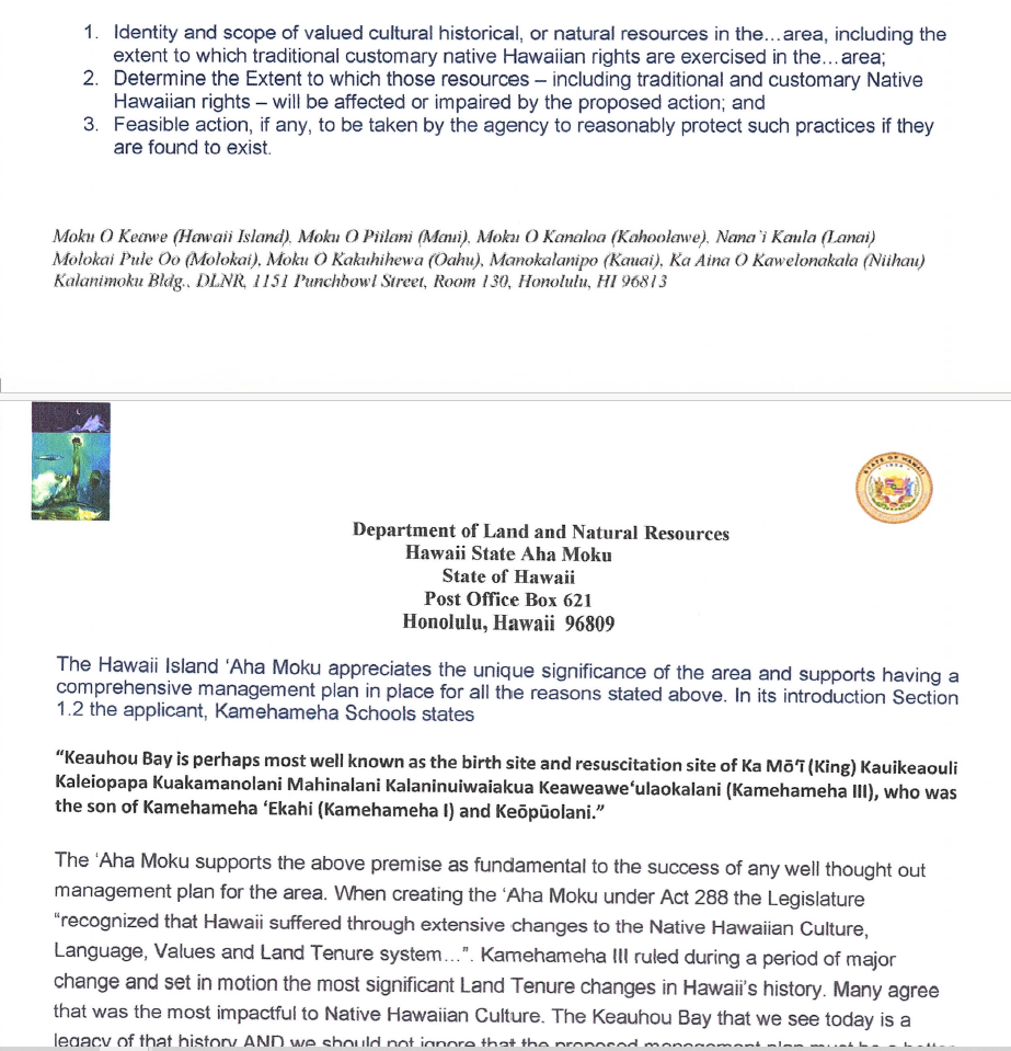
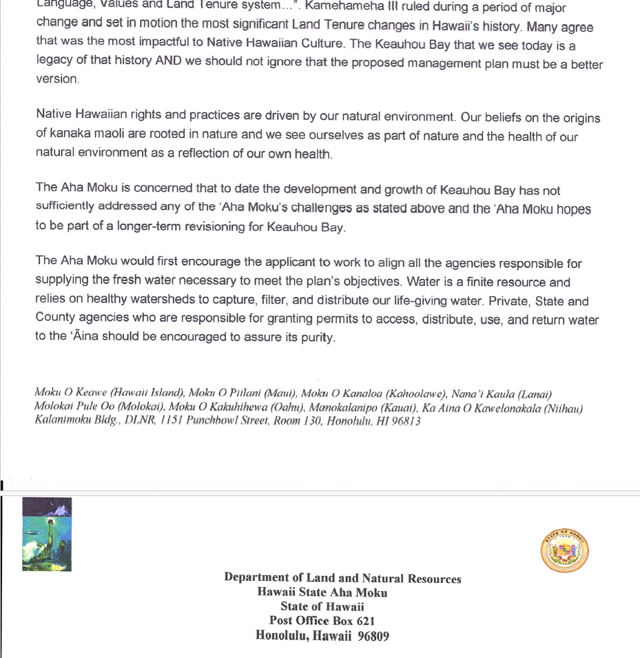
Photos of his emailed letter below.

Richard H. Bennett MS, PhD
Applied Life Sciences LLC
July 24, 2024, VIA EMAIL
COMMENTS REGARDING:
Draft Environmental Impact Statement
Photos Below Testimonial
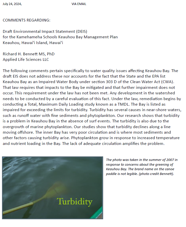
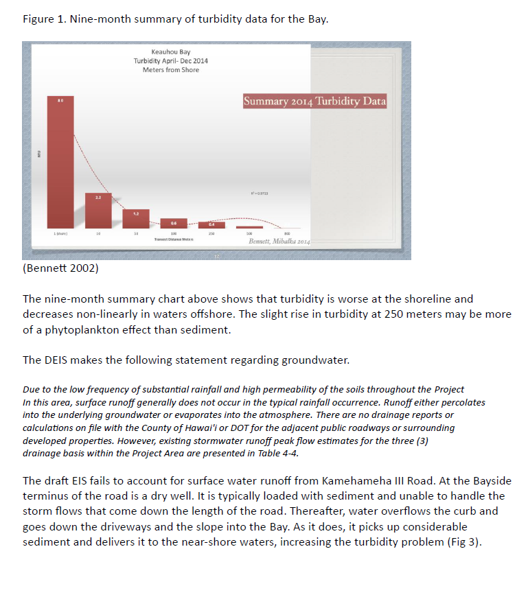
The following comments pertain specifically to water quality issues affecting Keauhou Bay. The draft EIS does not address these nor accounts for the fact that the State and the EPA list Keauhou Bay as an Impaired Water Body under section 303 D of the Clean Water Act (CWA). That law requires that impacts to the Bay be mitigated and that further impairment does not occur. This requirement under the law has not been met. Any development in the watershed needs to be conducted by a careful evaluation of this fact. Under the law, remediation begins by conducting a Total, Maximum Daily Loading study known as a TMDL. The Bay is listed as impaired for exceeding the limits for turbidity. Turbidity has several causes in near-shore waters, such as runoff water with fine sediments and phytoplankton. Our research shows that turbidity is a problem in Keauhou Bay in the absence of surf events. The turbidity is also due to the overgrowth of marine phytoplankton. Our studies show that turbidity declines along a line moving offshore. The inner Bay has very poor circulation and is where most sediments and other factors causing turbidity arise. Phytoplankton grow in response to increased temperature and nutrient loading in the Bay. The lack of adequate circulation amplifies the problem.
The photo was taken in the summer of 2007 in response to concerns about the greening of Keauhou Bay. The brand name on the canoe paddle is not legible. (photo credit Bennett).
2
Figure 1. Nine-month summary of turbidity data for the Bay.
(Bennett 2002)
The nine-month summary chart above shows that turbidity is worse at the shoreline and decreases non-linearly in waters offshore. The slight rise in turbidity at 250 meters may be more of a phytoplankton effect than sediment.
The DEIS makes the following statement regarding groundwater.
Due to the low frequency of substantial rainfall and high permeability of the soils throughout the Project
In this area, surface runoff generally does not occur in the typical rainfall occurrence. Runoff either percolates
into the underlying groundwater or evaporates into the atmosphere. There are no drainage reports or
calculations on file with the County of Hawai'i or DOT for the adjacent public roadways or surrounding
developed properties. However, existing stormwater runoff peak flow estimates for the three (3)
drainage basis within the Project Area are presented in Table 4-4.
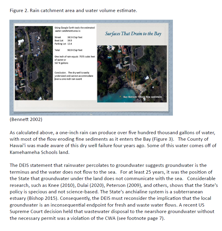
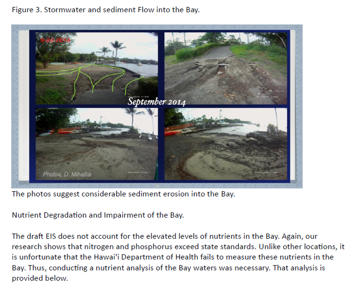
The draft EIS fails to account for surface water runoff from Kamehameha III Road. At the Bayside terminus of the road is a dry well. It is typically loaded with sediment and unable to handle the storm flows that come down the length of the road. Thereafter, water overflows the curb and goes down the driveways and the slope into the Bay. As it does, it picks up considerable sediment and delivers it to the near-shore waters, increasing the turbidity problem (Fig 3).
3
Figure 2. Rain catchment area and water volume estimate.
(Bennett 2002)
As calculated above, a one-inch rain can produce over five hundred thousand gallons of water, with most of the flow eroding fine sediments as it enters the Bay (Figure 3). The County of Hawai'i was made aware of this dry well failure four years ago. Some of this water comes off of Kamehameha Schools land.
The DEIS statement that rainwater percolates to groundwater suggests groundwater is the terminus and the water does not flow to the sea. For at least 25 years, it was the position of the State that groundwater under the land does not communicate with the sea. Considerable research, such as Knee (2010), Dulai (2020), Peterson (2009), and others, shows that the State's policy is specious and not science-based. The State's anchialine system is a subterranean estuary (Bishop 2015). Consequently, the DEIS must reconsider the implication that the local groundwater is an inconsequential endpoint for fresh and waste water flows. A recent US Supreme Court decision held that wastewater disposal to the nearshore groundwater without the necessary permit was a violation of the CWA (see footnote page 7).
4
Figure 3. Stormwater and sediment Flow into the Bay.
The photos suggest considerable sediment erosion into the Bay.
Nutrient Degradation and Impairment of the Bay.
The draft EIS does not account for the elevated levels of nutrients in the Bay. Again, our research shows that nitrogen and phosphorus exceed state standards. Unlike other locations, it is unfortunate that the Hawai'i Department of Health fails to measure these nutrients in the Bay. Thus, conducting a nutrient analysis of the Bay waters was necessary. That analysis is provided below.
5
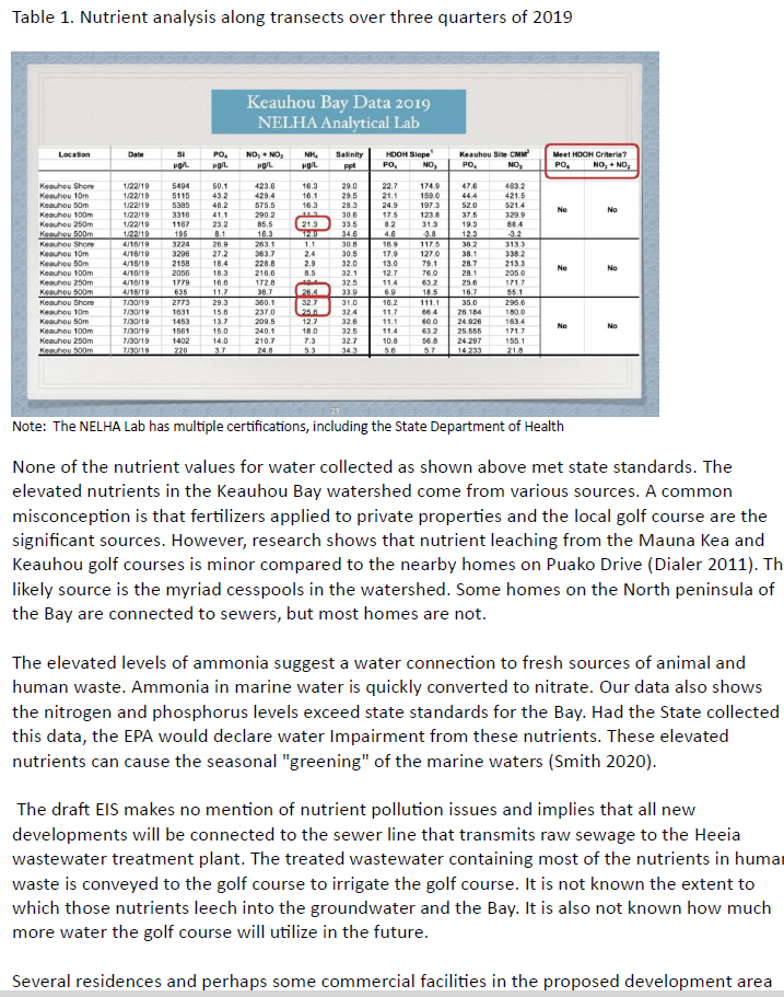
Table 1. Nutrient analysis along transects over three quarters of 2019
Note: The NELHA Lab has multiple certifications, including the State Department of Health
None of the nutrient values for water collected as shown above met state standards. The elevated nutrients in the Keauhou Bay watershed come from various sources. A common misconception is that fertilizers applied to private properties and the local golf course are the significant sources. However, research shows that nutrient leaching from the Mauna Kea and Keauhou golf courses is minor compared to the nearby homes on Puako Drive (Dialer 2011). The likely source is the myriad cesspools in the watershed. Some homes on the North peninsula of the Bay are connected to sewers, but most homes are not.
The elevated levels of ammonia suggest a water connection to fresh sources of animal and human waste. Ammonia in marine water is quickly converted to nitrate. Our data also shows the nitrogen and phosphorus levels exceed state standards for the Bay. Had the State collected this data, the EPA would declare water Impairment from these nutrients. These elevated nutrients can cause the seasonal "greening" of the marine waters (Smith 2020).
The draft EIS makes no mention of nutrient pollution issues and implies that all new developments will be connected to the sewer line that transmits raw sewage to the Heeia wastewater treatment plant. The treated wastewater containing most of the nutrients in human waste is conveyed to the golf course to irrigate the golf course. It is not known the extent to which those nutrients leech into the groundwater and the Bay. It is also not known how much more water the golf course will utilize in the future.
Several residences and perhaps some commercial facilities in the proposed development area use cesspools or septic systems for human waste management. The impact on the Bay is significant and needs to be described and mitigated. However, this problem is not mentioned in
6
the DEIS. It is more than advisable that the Project connect all waste systems to the regional sewer.
It is well established that sewer lines leak, which is a function of many factors such as piping class and age (Rutch 2006). In the project area, some sewer lines are quite old. One such line on the East shore of the Bay broke during a significant tidal event. The DEIS does not account for sewer line leakage or the risk from extreme tidal events. This problem needs to be evaluated, and where sewer lines are at risk and need to be replaced by resilient lines such as High-Density Polyethylene (HDPE).
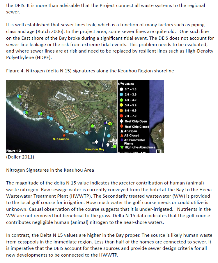
Figure 4. Nitrogen (delta N 15) signatures along the Keauhou Region shoreline
(Dailer 2011)
Nitrogen Signatures in the Keauhou Area
The magnitude of the delta N 15 value indicates the greater contribution of human (animal) waste nitrogen. Raw sewage water is currently conveyed from the hotel at the Bay to the Heeia Wastewater Treatment Plant (HWWTP). The Secondarily treated wastewater (WW) is provided to the local golf course for irrigation. How much water the golf course needs or could utilize is unknown. Casual observation of the course suggests that it is under-irrigated. Nutrients in the WW are not removed but beneficial to the grass. Delta N 15 data indicates that the golf course contributes negligible human (animal) nitrogen to the near-shore waters.
In contrast, the Delta N 15 values are higher in the Bay proper. The source is likely human waste from cesspools in the immediate region. Less than half of the homes are connected to sewer. It is imperative that the DEIS account for these sources and provide sewer design criteria for all new developments to be connected to the HWWTP.
7
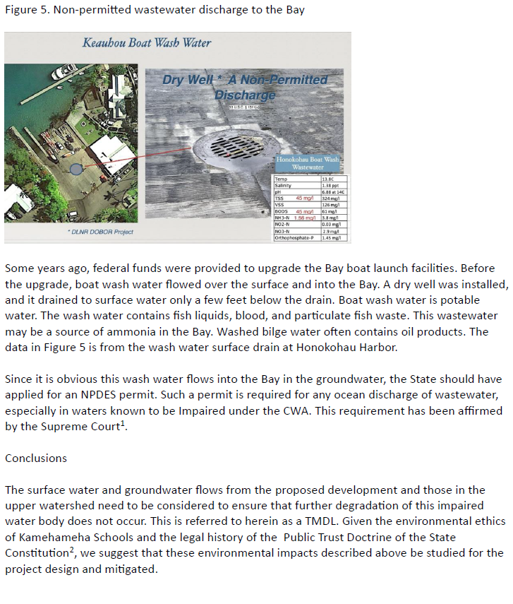
Figure 5. Non-permitted wastewater discharge to the Bay
Some years ago, federal funds were provided to upgrade the Bay boat launch facilities. Before the upgrade, boat wash water flowed over the surface and into the Bay. A dry well was installed, and it drained to surface water only a few feet below the drain. Boat wash water is potable water. The wash water contains fish liquids, blood, and particulate fish waste. This wastewater may be a source of ammonia in the Bay. Washed bilge water often contains oil products. The data in Figure 5 is from the wash water surface drain at Honokohau Harbor.
Since it is obvious this wash water flows into the Bay in the groundwater, the State should have applied for an NPDES permit. Such a permit is required for any ocean discharge of wastewater, especially in waters known to be Impaired under the CWA. This requirement has been affirmed by the Supreme Court1.
Conclusions
The surface water and groundwater flows from the proposed development and those in the upper watershed need to be considered to ensure that further degradation of this impaired water body does not occur. This is referred to herein as a TMDL. Given the environmental ethics of Kamehameha Schools and the legal history of the Public Trust Doctrine of the State Constitution2, we suggest that these environmental impacts described above be studied for the project design and mitigated.
1 County of Maui, Hawaii v. Hawaii Wildlife Fund, 140 S. Ct. 1462, 590 U.S. 165, 206 L. Ed. 2d 640 (2020). 2 Kelly v. 1250 Oceanside Partners, 140 P.3d 985, 111 Haw. 205 (2006).
8
Keauhou Bay is a small bay inlet on Hawai'i Island and, as such, is subject to much more degradation than the open shore area of West Hawai'i. As such, the Bay requires special protections.
Sincerely,
/s R.H. Bennett MS, PhD, President
References
Bennett, R. H. The Impaired Waters of Keauhou Bay, Hawai'i Island 2022. https://www.youtube.com/watch?v=pk_-Q25bX0s
Bishop, Renée E., William F. Humphreys, Neven Cukrov, Vesna Žic, Geoff A. Boxshall, Marijana Cukrov, Thomas M. Iliffe et al. "'Anchialine'redefined as a subterranean estuary in a crevicular or cavernous geological setting." Journal of Crustacean Biology 35, no. 4 (2015): 511-514.
Dailer, M, Smith, C., Glenn, C. Preventing the introduction and spread of nutrient driven invasive algal blooms and coral reef degradation in West Hawai'i, University of Hawai'i, Manoa, Grant Number NA09NOS4260242, 9/30/2011
Dulai, Henrietta, Catherine Hudson, Trista McKenzie, Brytne Okuhata, Diamond K. Tachera, and Aly El-Kadi, 2021. Geochemical Signatures of Coastal Groundwater Reflect Groundwater Flow Lines and Land-Uses in West Hawai'i. Submarine Groundwater Discharge session, GDEs; International Tropical Islands Water Conference; University of Hawaii at Manoa, Honolulu, HI (via videoconference).
Knee, Karen L., Joseph H. Street, Eric E. Grossman>, Alexandria B. Boehm, and Adina Paytan. "Nutrient inputs to the coastal ocean from submarine groundwater discharge in a groundwater-dominated system: Relation to land use (Kona coast, Hawaii, USA)." Limnology and Oceanography 55, no. 3 (2010): 1105-1122.
Peterson, Richard N., William C. Burnett, Craig R. Glenn, and Adam G. Johnson. "Quantification of point-source groundwater discharges to the ocean from the shoreline of the Big Island, Hawaii." Limnology and Oceanography 54, no. 3 (2009): 890-904.
9
Rutsch, M., J. Rieckermann, and P. Krebs. "Quantification of sewer leakage: a review." Water Science and Technology 54, no. 6-7 (2006): 135-144.
Smith, Joseph S., Ryan J. Winston, R. Andrew Tirpak, David M. Wituszynski, Kathryn M. Boening, and Jay F. Martin. "The seasonality of nutrients and sediment in residential stormwater runoff: Implications for nutrient-sensitive waters." Journal of environmental management 276 (2020): 111248.
Pictures of the photos and graphs he mentions in his letter above.
To: County of Hawai‘i, Planning Department
Alex Roy, (808) 961-8140, Alex.Roy@hawaiicounty.gov
Aupuni Center, 101 Pauahi St., Suite 3, Hilo, HI 96720
Dear County of Hawaii, Planning Department,
This letter serves as comments to the Keauhou Bay Management Plan Draft EIS (the "Project"). As discussed below, I am an expert in environmental forensics and I have experience with the assessment of the impact of pollutants on bodies of water. As the Editor of the Environmental Forensics Journal, I have peered reviewed hundreds of articles, including those with studies related to impact of pollutants on bodies of water and sediments including in the marine environment. I have reviewed portions of the EIS and provide the following comment about additional studies and research that, in my opinion, are needed to assess the environmental impact of the Project on Keauhou Bay.
My Background
I am a biochemist with 30 years of experience including basic and applied research related to environmental contaminants focused on fate & transport evaluations. I have applied a variety of environmental forensic/fingerprinting methods to track the source and age-date environmental
contaminants in water, soil, and air (including chlorinated solvents, PFAS, crude oil and petroleum products, metals, PCBs, perchlorate, nutrients, and 1,4-dioxane). I am the Editor-in-Chief of Environmental Forensics Journal and the author of the textbook “Environmental Forensics Fundamentals: A Practical Guide”. Over the years, I have published over seventy scientific articles and an invention patent, and provided numerous presentations, workshops, and courses on environmental forensics. I am actively involved with Interstate Technology and Regulatory Council (ITRC). As a member of the ITRC’s PFAS (per- and polyfluoroalkyl substances) team, I am currently actively contributing to several sections of the PFAS technical guideline document, including those on aqueous film forming foams (AFFFs), fate and transport and source evaluations. I have also conducted innovative research for U.S. DOE, U.S. DoD, and the European Community on environmental characterization, risk assessment, and innovative remedial technologies for soils, sediments, and water. A copy of my CV is attached.
Comment
Studies Are Needed to Assess The Environmental Impact of Additional Pollutants On Keauhou Bay
The Project proposes to construct a 150-unit resort in an existing forested area, build a number of commercial kiosks, construct a cultural center and construct roughly 14,000 feet of retail/commercial space on and/or adjacent to Keauhou Bay. This also includes the construction of additional roads and a significant amount of hardscape. The project proposes to remove a large amount of existing historical forest area that may be capturing pollutants from the golf course and preventing them from entering the bay. The Project will likely increase the number of visitors and vehicles around the bay, which is likely to increase the quantity of pollutants that may enter the bay and effect flora and fauna within the bay. A study needs to be done to assess existing pollutant loading to the bay from the surrounding properties. This would likely include sampling any runoff to the bay, including from the golf course and runoff from the existing parking lots, as well as core sampling within the bay to assess the level of pollutants within the sediment and to evaluate the historical pollutant loading in the bay that are currently impacting flora and fauna (and water quality) within the bay. Note that while the EIS suggests that rainfall on the project site may percolate in the subsurface rather than running into the bay, it is my understanding (based on discussion with locals) that there is current flooding experienced on nearby Kamehameha III drive during rain events (with part of the flooding potentially originating from Project lands) and in the past rain events have washed out the 2nd volleyball court that was located to the west of the remaining court. It appears that, at least at times, runoff does get into the bay and that should be considered. Moreover, locals have reported that the East end of the bay has gotten noticeably shallower in recent years, suggesting that sedimentation of the bay is occurring. Overall, there appears to be evidence that historical land clearing in the area has led to increased runoff from the Project area. Moreover, the project proposes to remove 10+ acres of heavily forested land and replace it with roads, parking lots, buildings and other hardscape. That forested land receives runoff from the golf course area uphill of the forested area. One would expect forested area to slow down rainfall and reduce runoff the upper portions of the project area and golf course. As Kailua-Kona receives rainfall from periodic tropical storms and/or remnants of hurricanes where several inches of rain can fall within a couple of days, the project needs to study rainfall from large episodic events and the impact on the bay. In particular, with the forest gone and replaced by roads, parking lots, buildings and other hardscape, that water can no longer percolate and will be added runoff. None of this analysis was apparently conducted.
An assessment should then include projections as to the amount of the potential increases in the quantity of pollutants entering the bay from the Project, assess potential mitigation measures and assess the ecological impact from the runoff.
In conclusion, the EIS as written fails to include studies necessary to assess historical and ongoing impacts to the bay, future impacts to the bay from the Project, and potential mitigation measures to address historical issues caused by Proponents lands, if any, and future impacts from the proposed Project.
Sincerely,
Ioana G. Petrisor, Ph.D.
Editor-in-Chief
Environmental Forensics Journal
July 18, 2024
County of Hawaiʻi, Planning Department
Alex Roy
Phone: (808) 961-8140
Email: Alex.Roy@hawaiicounty.gov
Aupuni Center
101 Pauahi St., Suite 3
Hilo, HI 96720
Keauhou Bay Management Plan Draft Environmental Impact Statement Comments
Dear Mr. Roy,
I would like to start by introducing myself, I am the founder and President of Great Ecology, a leading ecological consulting and landscape architecture firm. Formed in 2001, Great Ecology has used ecological approaches to address environmental challenges and regulations for over two decades now. I have over 30 years of experience as an expert technical consultant on over 1,400 projects across the United States and internationally. My technical specializations include habitat restoration, ecological planning and design, and environmental strategy.
The purpose of this letter is to provide comments on the Kamehameha Schools, Keauhou Bay Management Plan Draft Environmental Impact Statement (DEIS). It is the responsibility of the party preparing the DEIS to provide substantial evidence to support the analysis and conclusions of the DEIS; however, this DEIS falls short of that. The majority of the DEIS seems to be a series of unsupported conclusions and not a DEIS that is supported by substantive research or analysis. The comments below are not all-inclusive but are intended to highlight the deficiencies of the DEIS.
2
Congestion and Use Conflict
The DEIS argues that Keauhou Bay (Bay) suffers from “congestion” and conflicts with incompatible uses, however there is no study analyzing congestion (i.e., number of users over a given time span such as daily, weekly, monthly, etc. basis). Additionally, the DEIS does not evaluate how the Project, implementation of the Keauhou Bay Management Plan on approximately 29 acres of Keauhou Bay, would reduce the existing number of users or implied incompatible uses, other than reducing access to publicly owned space. Without the required analysis, the claim that the Project would reduce congestion and/or use conflicts is unsupported. In actuality, it may be reasonable to conclude that the Project would increase congestion and use conflicts at Keauhou Bay with the proposed construction of 43 homes, cultural center, commercial center, and commercial kiosks. The DEIS identifies the launch ramp stretch as an area of greatest congestion, however it proposes to add a substantial number of visitors and vehicles to that area, thereby increasing congestion further. The DEIS fails to provide any explanation as to how adding thousands of people and vehicles to areas identified as having the greatest congestion will be reduced by the Project. There is also no analysis in the DEIS of the impact on local plants or wildlife from the likely increased usage of the Bay because of the Project. Lastly, there is no analysis of future impacts on the existing uses of the Bay with the addition of rental kayaks and stand-up paddle boards to the Bay. The reasons listed above demonstrate that the DEIS has failed to provide the required analyses and supporting evidence.
Traffic Impacts
The Project proposes to build a resort with 43 multi-bedroom houses, commercial kiosks, a cultural center, a commercial/retail center, as well as a road connecting the north and south ends of the Bay. This will result in a large amount of vehicle trips per day, however there is no study analyzing traffic impacts. There is also no evidence of what the amount of reduction on the existing roadways would be with construction of a new road. The DEIS also fails to address how the Project would mitigate increased traffic impacts. Lastly the DEIS claims that the Project will reduce traffic impacts but does not provide any substantiation or studies to support its conclusions.
3
Noise Impacts
The DEIS fails to adequately address noise impacts from the Project. The majority of the project will remove historically forested areas, from which the only noises emanating are natural sounds. There are no studies of the existing noise levels in the area or studies of what increased noise impacts to the area will be, except statements that are made without any supporting evidence. It is obvious that the Project will alter existing conditions related to noise via a large increase in human and motorized activity in and around the Bay.
Air Impacts
The DEIS fails to address air impacts from the Project. As mentioned previously, a large number of additional motorized vehicles and vessels will be added to the area. However, there have been no studies of existing air quality conditions relative to the projected conditions with more vehicular traffic.
Historical Runoff Issues
The DEIS does not address how the Project will address manage flooding on Kamehameha II Drive caused by Project lands. The DEIS does not address that there were two sand volleyball courts historically. The second court was located in the publicly owned land between the seawall and existing volleyball court. When the Project proponent cleared lands to construct the existing parking lot and boat storage area, stormwater drainage was considerably affected. As a note, the DEIS fails to address the permit status of the existing boat storage and parking lot. The Project proponent failed to make repairs to the second sand volleyball court and the EIS fails to address what appears to be unpermitted development of the current northern parking lot and boat storage lot, or their environmental impacts. The DEIS does not address the historical catchment area north of the sand volleyball court, which historically helped to capture runoff from the northern area where the new parking lots and boat storage were added. The Project proponent has failed to maintain the catchment, which has caused excess runoff from the area resulting in damage to publicly-owned property. The DEIS needs to address the permit status of the apparently illegally constructed parking and boat parking lots including the lack
4
of environmental review, the historical runoff issues from the Project proponent lands that have damaged publicly owned property, and the strategy to mitigate existing issues.
Runoff Impacts from Increased Hardscape
The Project fails to address additional runoff impacts from increased hardscape. The Project proposes to remove existing native vegetation in favor of construction of the resort, commercial kiosks, and commercial/retail spaces. According to the Project maps, it appears that about 15-20 acres of native vegetation will be removed and replaced with mostly hardscape. There is no analysis of the current conditions or of the increased flow and rate of runoff from the increased hardscape. The same conclusion can be drawn here – that the DEIS has failed to provide the appropriate analysis and documentation to support its conclusions.
Toxicity and Eutrophication
The Project fails to study, analyze, and/or provide projection as to increased toxicity and eutrophication impacts to Keauhou Bay. The decision to position the roadway closer to the Bay increases the potential for toxic pollutants entering the Bay and impacting the Bay’s ecosystem. There is no study on the existing toxicity of runoff to the Bay from nearby roadways nor is there a study or projection of the concentration or ecological impact of the Project on future runoff to the Bay. Projects such as resorts with houses, pools, lawns etc. have increased runoff of nitrates and phosphates, which are known to cause eutrophication to water bodies. Golf courses have the potential to release substantial amounts of nitrates and phosphates through runoff. The forested area that the golf course drains into is proposed to be removed by the Project. The DEIS fails to analyze existing conditions as well as impacts of removal of the forest and the construction of the resort and roads on future releases of eutrophic chemical to the Bay. The DEIS is failing to provide the supporting evidence and documentation required in a DEIS.
5
Proponents Failure to Maintain Existing Facilities
The DEIS does not analyze the long history of the Project proponent’s failure to maintain existing properties. The DEIS suggests that the long-term maintenance issues related to the Project proponent’s properties are due to lack of income from the properties and that in the future, maintenance will improve. According to the Project proponent’s website their endowment is valued at $14.6 billion suggesting lack of funds should not be an issue contributing to lack of maintenance. Additionally, the Project proponent has historically received funds from the Keauhou properties through the boat yard rental, parking, canoe club, and building rentals. There is little evidence to support that if the Project is approved, the Project proponent would conduct the required maintenance. An example is the existing seawall owned by the Project proponent, which has been in serious disrepair for over a decade with pieces falling into the ocean and no repairs made. As a result, the DEIS should consider the very likely scenario that the Project proponent may continue to act as it has historically and fail to maintain its properties.
Public Access
The Project appears to block public access across publicly owned property. According to the maps attached to the EIS, there is publicly owned property extending from the end of Kamehameha III Drive to the boat dock area. There is currently a path that extends from the end of Kamehameha III Drive to the boat dock area that allows access to the boat dock area, however, the Project proposal maps appear to block the publicly owned path. It appears that the Project proposes to block access to the public across publicly owned property.
Destruction of the Sand Volleyball Courts
There were two sand volleyball courts located on the east end of Keauhou Bay historically. According to locals, the existing volleyball court located at the western edge of the Project proponent’s property has been in continuous use by the public. Due to the limited availability of volleyball courts locally, this is the primary one used by local adults and children. Until the Project proponent cleared land to create the northern parking lot and boat parking, there was a second court that was similarly used. The Project proponent proposes to eliminate both volleyball courts and instead
6
plant grass in the area as “open space.” The DEIS does not analyze the impacts of eliminating the existing volleyball court nor the impact on the local community who enjoy it. The Project does not include replacing the second volleyball court that was damaged by the excess runoff caused by prior land clearing. Lastly, a large grassy area is incompatible with historical and current uses of that area. Historical photographs show the East end of Keauhou Bay as sandy beach all the way up to the base of the hill to the East of the existing volleyball court.
The analysis presented to support the claims made in the DEIS is insufficient, therefore the DEIS should not be certified until substantial evidence to support these claims is provided in a supplemental DEIS to meet the requirements and rules of NEPA (CEQ Regulations (40 CFR 1502.9(b))) for certification.
Sincerely,
Mark S. Laska, Ph.D.
President and CEO
Photos are from his actual letter sent.
220 West Gutierrez Street • Santa Barbara, California 93101
July 19, 2024
County of Hawai‘i, Planning Department
Aupuni Center, 101 Pauahi St., Suite 3
Hilo, HI 96720
Attention: Alex Roy
Re: Kamehameha Schools, Keauhou Bay Management Plan Draft Environmental Impact Statement
To County of Hawaii, Planning Department,
I am submitting these comments to the Kamehameha School, Keauhou Bay Management Plan Draft Environmental Impact Statement (the "Project"). As an initial matter, I have over 30 years experience as an environmental hydrogeologist including extensive work on environmental impact assessments including impact of contaminants and sedimentation of water bodies. I have previously rented a house located on the bay and visited the bay numerous times such that my comments include personal observations. The focus of my comments is on the substantial lack of the necessary foundational studies upon which to base an assessment of the Project impact. My comments are as follows:
A. Background Expertise
Currently, I am President of LEA Environmental, Inc., an environmental hydrogeology and remediation company. I have over 30 years of experience in environmental science, hydrogeology and surface water, groundwater and soil contamination.
During the course of my career, I have evaluated groundwater and surface water quality at more than 200 sites around the country. My professional work experience includes conducting site investigations to define the causes, nature and extent of contamination, groundwater and surface water modeling, conducting contaminant fate and transport studies, evaluating pathways for human exposure and assessing remediation strategies. My technical expertise includes the evaluation of fate and transport of chemicals of concern in multiple phases in the environment.
I am a Professional Geologist (CA PG #7212), licensed by the California Board for Professional Engineers, Surveyors and Geologists. I earned a PhD in Geological Sciences from the University of Washington in 1990. I earned a Master’s of Science Degree in Geological Sciences from the University of Washington in 1986. I earned a Bachelor’s Degree in Earth Sciences from Dartmouth College in 1981.
I am a member of the Editorial Board of the journal, Environmental Forensics, a quarterly peer-reviewed scientific journal of national and international circulation. In this role, I evaluate the work of others through peer-review of manuscripts submitted for publication to the journal. I also participate in publication decisions, as well as establishing and maintaining the editorial direction of the journal.
I was appointed by the State of California Department of Toxic Substances Control (“DTSC”) and South Coast Air Quality Management District (“AQMD”) to serve as the Technical Advisor to the Exide Community Advisory Group. In this capacity, I serve as technical liaison between community stakeholders and state regulators for the Exide Residential Cleanup Project involving evaluation and cleanup of up to 10,000 homes impacted by lead emissions from a secondary lead smelter. The Exide residential cleanup is the largest soil remediation project ever undertaken in California. I have provided expert testimony on the Exide case before a legislative hearing at the state capitol in Sacramento. I have
July 19, 2024
Page 2 of 2
also testified twice before the U.S. House of Representatives’ Committee on Natural Resources on environmental matters. My team at LEA and I currently serve as Third Party Monitors for the Exide cleanup. A copy of my resume is provided as an attachment to this letter.
B. Substantive Comments
As noted below, my overall conclusion is that the EIS lacks many of the basic foundational studies of existing conditions within the bay necessary to assess the potential impacts of the project and also assess potential mitigation measures. In particular, studies are needed of the existing sediments (quality and quantity) within the bay to quantify existing ecological health and credible projections are needed of potential project impacts in order to incorporate appropriate mitigation measures
The Project proposes to remove acres of forest surrounding Keauhou Bay.to construct a resort comprised of 43 homes with 150 bedrooms, build a new road connecting the north and south ends of the bay, build commercial kiosks, construct a cultural center and construct a commercial/retail center on the eastern end of the bay. As you are aware, coral, fish and other flora and fauna can be particularly susceptible to harm from excess sediment, salinity balances, toxic pollutants and nutrient loading in shallow water bodies like Keauhou Bay. In order to determine what the potential ecological impacts to the bay might be there needs to be a baseline study conducted of the existing sediments within the bay to determine the historical sedimentation rate, quantify the existing pollutant and nutrient loads within those sediments, identify the source(s) of sediments/pollutants/nutrients. In turn, this baseline analysis would contribute to the necessary analysis of potential impacts from the Project, including an analysis of mitigation measures, if any, that might be needed to protect sensitive flora and fauna within the bay, including coral communities.
Once the baseline study is conducted the EIS should provide predictions of Project impacts to the bay, including impacts from the removal of the forest, increased hardscape, and increased potential for pollutants and sediment to enter the bay from both construction activities but also new roads and housing. Once the potential impacts are analyzed, mitigation measures should then be assessed and required, if necessary) that could minimize the impact on the bay. Without the foregoing analysis, I do not believe the EIS can meet its obligation of determining the magnitude of potential Project impacts on the ecology, nor identify mitigation measures that could bring the impacts down to an acceptable level, if needed.
Conclusion
The purpose of an EIS is to conduct sufficient research and studies to inform decision-makers and the public of potential Project impacts. This clearly requires an understanding of baseline conditions. In this instance, it does not appear that adequate studies have been conducted of the bay to assess existing conditions nor analyze the potential impacts from the Project so as to both assess potential mitigation measures but also inform the public and regulatory agencies of the Project impacts.
Thank you for considering these comments and concerns.
Sincerely,
James T. Wells, PG, PhD
James T. Wells, PhD, PG
Environmental Geologist
LEA Environmental, Inc.
220 W. Gutierrez Street
Santa Barbara, CA 93101
Dr. Wells is an environmental geologist with over 30 years of experience in hydrogeology and geochemistry and is a Professional Geologist, licensed by the California Board for Engineers, Land Surveyors and Geologists. Dr. Wells is President of LEA Environmental, Inc., an environmental hydrogeology and remediation company. He earned his PhD in Geological Sciences from the University of Washington in 1990; Masters of Science Degree in Geological Sciences from the University of Washington in 1986; and his Bachelor’s Degree in Earth Sciences from Dartmouth College in 1981.
During the course of his career, Dr. Wells has evaluated soil, soil vapor and groundwater at dozens of sites around the country. His professional work experience includes conducting subsurface investigations to define the nature and extent of contamination in soil, soil vapor and groundwater, groundwater modeling, conducting contaminant fate and transport studies, and evaluating remediation strategies. He has extensive experience in groundwater and vadose zone computer modeling, as well as in the statistical analysis of hydrogeological systems. Dr. Wells is regularly asked to serve as an expert witness in environmental lawsuits involving subsurface contamination.
Dr. Wells is a member of the Editorial Board of the journal, Environmental Forensics, a quarterly peer-reviewed scientific journal of national and international circulation. In this role, he evaluates the work of others through peer-review of manuscripts submitted for publication to the journal. He also participates in publication decisions, as well as establishing and maintaining the editorial direction of the journal. He has given technical presentation and guest lectures at scientific conferences and universities and is author and coauthor of numerous scientific publications, including the forensic review articles in Environmental Science & Technology (U.K. Edition) Special Issue dedicated to Environmental Forensics.
In 2015, Dr. Wells was appointed by the State of California Department of Toxic Substances Control and South Coast Air Quality Management District to serve as the Technical Advisor to the Exide Community Advisory Group. In this capacity, he serves as technical liaison between community stakeholders and state regulators for this project involving evaluation and cleanup of up to 10,000 homes impacted by lead emissions from a secondary lead smelter. Dr. Wells has provided expert testimony on the Exide case before a legislative hearing at the state capitol in Sacramento. He has also twice testified before the U.S. House of Representatives Natural Resource Committee on environmental matters.
Education
University of Washington, Ph.D., Geological Sciences, 1990
University of Washington, M.S., Geological Sciences, 1986
Dartmouth College, B.A., Earth Sciences, 1981
Professional Registration
2001/California: Professional Geologist (Reg. No. 7212)
Professional Societies
Geological Society of America
American Ground Water Association
American Chemical Society
International Society of Environmental Forensics
James T. Wells, PhD, PG
Page 2
Applies expertise in geo-chemistry and hydrogeology to solve environmental problems
Employment History
LEA Environmental/L. Everett & Associates. 2010-present
Haley & Aldrich. 2006-2010
Shaw Environmental. 2005-2006
Haley & Aldrich. 2001-2005
Ogden Environmental. 2000-2001
Metcalf & Eddy. 1991-2000
Representative Project Experience
San Roque Cleanup Fund – Groundwater Remediation, Santa Barbara, CA. Groundwater and soil vapor monitoring, vapor intrusion mitigation, and in-situ groundwater remediation at a site with comingled plumes from four different dry cleaners. Developed conceptual site model and collected corroborating data to persuade Regional Water Quality Control Board to name additional responsible parties.
CA Department of Toxic Substances Control (DTSC) – Exide Technical Advisor, Vernon, CA. Appointed by DTSC and South Coast Air Quality Management District to serve as the Technical Advisor to the Exide Technologies Advisory Group. Has served since 2015 as technical liaison between community stakeholders and state regulators for this project involving evaluation and cleanup of up to 10,000 homes impacted by lead emissions from a secondary lead smelter. In addition to speaking at many community meetings, Dr. Wells provided expert testimony on the Exide case before a legislative hearing at the state capitol in Sacramento.
Hope Ranch Air Quality Assessment, Santa Barbara, CA. Tested indoor and outdoor air quality, sampled source area emissions at a unique phenomenon involving spontaneous combustion of organic matter in marine sediments exposed along Santa Barbara’s coastal bluffs. Determined the smoldering rocks were emitting problematic levels of benzene and other VOCs which reached nearby homes, constituting a nuisance and a potential health risk.
Magnolia Elementary School – Litigation Support, El Cajon, CA. Combined monitoring data and modeling to reconstruct historical groundwater and indoor air impacts at an elementary school adjacent to aerospace parts manufacturer.
SIMA Corporation – Chlorinated Solvents, Camarillo, CA. Conducted site characterization, subsurface remediation, regulatory negotiation for PCE in soil, soil vapor and groundwater at this dry cleaner site, with special emphasis on the potential for vapor intrusion into nearby commercial buildings.
Earthjustice – Evaluation of Neighborhood Lead Impacts, City of Industry, CA. Worked with the nonprofit environmental law organization, Earthjustice, to identify deficiencies in soil sampling plans and statistical analyses that were
James T. Wells, PhD, PG
Page 3
His area of expertise includes environmental forensics and fate and transport of organic and inorganic contaminants in soil and groundwater
meant to measure lead impacts due to emissions from the Quemetco Secondary Lead Smelter to soil in surrounding residential neighborhoods.
Elem Indian Colony – Mercury and Arsenic-Bearing Mine Waste, Clearlake, CA. Served as independent technical advisor to the Elem Indian Colony regarding remediation plans for the Sulphur Bank Mercury Mine Superfund Site. Provided assistance through EPA’s TASC (Technical Assistance Services for Communities) program.
Humphrey, Farrington & McClain – Radionuclides in West Lake Landfill Superfund Site, St. Louis, MO. Provided expert opinions on threats to human health and the environment from radioactive waste and other contaminants that had been improperly disposed of in this landfill in the early 1970s. The material consisted of uranium-ore-processing residues that had been generated in St. Louis as part of the Manhattan Project in the 1940s.
Reedley Remediation Trust – Chlorinated Solvents, Reedley, CA. Provided site characterization and remediation planning advice for this comingled PCE groundwater plume. Also advised on the formation of a remediation trust to insure adequate resources for a long-term cleanup program.
Isola Law Group – Rialto-Colton Superfund Site, San Bernardino County, CA. Provided litigation support in complex, multi-party lawsuit concerning cost allocation, contaminant fate and transport and remediation technologies for large (5-mile long) perchlorate and TCE groundwater plume.
San Carlos Apache Tribe – Technical Advice on Proposed Copper Mine, Superior, AZ. Advised the Tribe on environmental aspects of large proposed copper mine project which the Tribe opposed. This work involved meetings and negotiations with mining company and officials of the US Forest Service regarding intergovernmental consultations and the EIS process, expert testimony in an administrative hearing, presentations at Tribal Council meetings, meetings in Washington DC with Council on Environmental Quality, EPA, USDA and Congressional staff. Testified before the U.S. House of Representatives Committee on Natural Resources.
KB Gardena – Litigation Support & Subsurface Remediation, Gardena, CA. Provided attorneys with technical advice and assistance with cost allocation strategy for multi-million dollar case with multiple PRPs. Conducted site remediation under existing warehouse for PCE, metals and other VOCs.
Pacific Gas & Electric Company – Forensic Geochemistry, Chico, CA. Analyzed high-resolution petroleum hydrocarbon data, including PIANO analysis, relative solubility and hydrocarbon weathering assessments to evaluate the theory that contamination discovered on client’s property originated from off-site sources and was not due to on-site releases. PIANO analysis is a forensic technique for complex hydrocarbon mixtures using gas chromatography to speciate individual hydrocarbon compounds and group the compounds into their molecular classifications: paraffins (P), isoparaffins (I), aromatics (A), naphthalenes (N) and olefins (O).
James T. Wells, PhD, PG
Page 4
Rand Family Trust – Petroleum Hydrocarbons, Santa Barbara, CA. Conducted site characterization and site remediation for a commercial site in Santa Barbara, California that was impacted with legacy contamination from a sawmill operation from the late 1800’s. Achieved closure of this case from the local regulatory agency.
U.S. EPA – Del Amo and Montrose Superfund Sites, Los Angeles County, CA. Provided independent technical analysis and advice to community group affected by two adjacent Superfund sites. Analysis of potential exposure scenarios and efficacy of remediation plans from PCBs, metals and VOCs from Superfund sites in Los Angeles under EPA’s TASC program (Technical Assistance Services for Communities).
Terracon, Inc. – Groundwater Modeling and Litigation Support, Weld County, CO. Complex construction defect case involving claims of $60 million in damage allegedly due to soil expansion caused by rising groundwater from irrigation of nearby golf course and residential areas. Opposing experts spent two years and $2 million on groundwater modeling which was eventually excluded from trial after we demonstrated unreliability and lack of relevance to judge.
Wagstaff & Cartmell – Chromium in Tannery Waste, St. Joe, MO. Provided litigation support for case in which tannery waste had been spread as a soil amendment over approximately 56,000 acres of agricultural land. It had been known that the sludge contained elevated levels of metals, including chromium. It was apparently not known that some of the chromium was in the form of toxic Cr(VI) which posed a serious risk to human health and the environment.
EPA/State of Idaho – Soil Remediation Pilot Study for Metal Stabilization, Coeur d’Alene, ID. Conducted field pilot study on metal stabilization along the Coeur d’Alene River. The river feeds Lake Coeur d’Alene which is highly-impacted by the cumulative effects of 100 years of mining in the watershed and is the primary source of drinking water for over 50,000 residents of northern Idaho. Work was sponsored by the U.S. Environmental Protection Agency (EPA) and State of Idaho in an effort to find a cost-effective means of addressing widespread soil contamination along a 30 mile stretch of the Coeur d’Alene River.
Koch Oil – Forensic Geochemistry, Oklahoma. Conducted forensic geochemical evaluation on naturally-occurring compounds in groundwater to assess whether historical groundwater concentration trends constituted natural background variability or potential releases from client’s brine impoundments.
Tri-County Public Airport – Forensic Geochemistry Herington, KS. Conducted oxygen, deuterium, chlorofluorocarbon (CFC), carbon isotope analysis of groundwater and chlorinated contaminants in order of evaluate contaminant fate and transport at a former military facility.
Gonzalez & Robinson – Groundwater Modeling, Santa Rosa, CA. Used groundwater computer modeling to simulate groundwater flow in a residential region of Sonoma County, California.
James T. Wells, PhD, PG
Page 5
Weitz, Luxenberg – Environmental Forensics for Chlorinated Solvents, Grand Island, NE. Conducted forensic analysis of chlorinated solvent contamination extending in groundwater over two miles under a community. The site involved multiple releases from multiple locations and complex hydrogeology and attenuation histories.
Kimberly-Clark – Forensic Geochemistry, Ohio. Conducted forensic geochemical analysis to demonstrate that significant component of groundwater contamination under client’s site had migrated from an off-site source. Utilized compound-specific carbon isotope analysis of chlorinated compounds and daughter product abundance. This analysis was complicated by the fact that there were low levels of residual contamination from an old on-site release, which needed to be definitively differentiated from the larger off-site flux of contaminants.
Western States Petroleum Association – Risk-Based Clean-up Studies. Conducted a study to develop risk-based clean-up standards for crude-oil-impacted soils, including studies of the comparative environmental risks posed by crude oil, gasoline, and diesel oil in the subsurface. Applied leaking underground fuel tank evaluation methods to crude oil sites and developed cost-effective site assessment strategies.
Tesoro Petroleum Company –MTBE Groundwater Plume, San Fernando Valley, CA. Managed a project in Southern California to delineate and clean-up a large release of methyl tert-butyl ether (MTBE) to soil and groundwater. A particular challenge of this project was to account for the presence of multiple high-volume water supply wells near the project site, a situation involving extensive regulatory negotiation with California Regional Water Quality Control Board and Upper Los Angeles River Area Watermaster.
Gallagher & Kennedy – Perchlorate and Chlorinated Solvents, Santa Clarita, CA. Provided litigation support for a lawsuit involving a 996-acre brownfield site. The site, used since the 1930s for munitions manufacturing, had soil and groundwater contamination from historic releases of metals, perchlorate and chlorinated solvents. When the local municipality took 13 acres of the property by eminent domain to build a new regional highway, the property owner sued to recoup the cost of the land. The municipality estimated a cleanup cost of $220 million and, based on this, valued the land at only $142,000. With colleagues, developed a soil and groundwater remediation plan and cost estimate. Through extensive soil and groundwater data analysis and 3D modeling, we developed an alternative remediation plan that dovetailed with extensive pre-development grading and employed state-of-the-art remediation technologies for perchlorate at a cost $27 million. A jury accepted the accuracy of our remediation estimate and awarded the owner over $12 million for land value and severance damages.
ContiGroup Companies – Groundwater Remediation, Stockton, CA. Completed subsurface characterization and designed a remediation strategy for this grain elevator site with carbon tetrachloride and other volatile organic
James T. Wells, PhD, PG
Page 6
compounds in groundwater. Due to the complex stratigraphy and heterogeneous distribution of contaminant throughout the aquifer, an in-situ chemical treatment strategy was designed for this site coupled with an initial, short-term phase of groundwater extraction to achieve containment of the contaminant plume.
The Boeing Company – Service Delivery Leader, California. Served as Service Delivery Leader, responsible for coordinating quality and consistency for a project team located in six offices and providing environmental services simultaneously on up to ten large projects. Also conducted vadose zone computer modeling to evaluate clean-up standards for soil that would be protective of future groundwater quality.
Northrop-Grumman Corporation—Remediation Planning, Hawthorne, CA. Provided analysis of environmental data and regulatory requirements for large site with multiple occurrences of contamination in soil and groundwater. Advised client on cost-effective strategies and technologies for resolving environmental impairment.
Tesoro Petroleum Company – Groundwater Contamination at Refinery, Kenai, AK. Conducted a feasibility study for containment and remediation of a large plume of free phase petroleum at a refinery in Kenai, Alaska. Migration of the light non-aqueous phase liquid was influenced by complex fluvio-glacial stratigraphy and by fluctuating groundwater levels.
Exxon Company, U.S.A. – Remediation Planning, Los Angeles, CA. Developed remediation and regulatory strategies for the closure of a large urban oil field in California consisting of over 500 production sites over four square miles of residential and commercial districts. The proposed strategy was a risk-based approach addressing such factors as cost, schedule, future liability and land use.
The Boeing Company - Aircraft Manufacturing Site Redevelopment Environmental Program, Long Beach, CA. Team member for comprehensive subsurface investigation program for 343-acre former manufacturing facility. This complex project involved over 1500 soil borings, web-based data repository, risk-based formulation of clean-up standards, production of data reports specifically designed for use by potential buyers and other stakeholders and close coordination with redevelopment staff.
Nestlé, U.S.A. –Aquifer Remediation, Palm Desert, CA. Working with Nestlé technical staff, developed a technical strategy and gained regulatory acceptance of a passive bioremediation approach at an underground storage tank site which contained hydrocarbon contamination in groundwater in a beneficial-use aquifer.
County of San Luis Obispo Water Supply – Nitrate in Groundwater, Los Osos, CA. Conducted a study of nitrate contamination in shallow groundwater at Los Osos, California, a community that relies solely on groundwater for its municipal water supply. The study incorporated site-specific data on the transport and transformation of nitrogen in the subsurface to develop a nitrogen mass balance for all significant nitrate sources. This work resulted in quantitative
James T. Wells, PhD, PG
Page 7
estimates of the contribution of septic system effluent to nitrate levels in groundwater.
U.S. Navy – Groundwater Investigations and Remediation Planning, San Diego County, CA. Managed site investigations, feasibility studies and remediation planning at eight contaminated sites overlying the sole-source aquifer at Camp Pendleton Marine Corps Base.
Santa Barbara Historical Society – Manufactured Gas Plant Contamination, Santa Barbara, CA. Provided environmental consulting services, advocacy and participated in negotiations with Southern California Edison (the responsible party) on behalf a Santa Barbara nonprofit organization. This work focused on soil and groundwater investigations, remediation plans and associated risks related to soil and groundwater contamination at a former manufactured gas plant on the nonprofit’s property.
Sequoia Voting Systems – Groundwater Investigations, Exeter, CA. Managed a project involving chlorinated compounds in groundwater and developed strategy to suspend active remediation on the grounds of natural contaminant of the chlorinated plume. Our approach was approved by the state.
Los Angeles Metropolitan Transportation Authority – Comprehensive Environmental Services. Project manager for comprehensive hazardous waste assessment contract with the LACMTA. For this project, we provided environmental services in support of land acquisition and construction for a light-rail commuter line in the Los Angeles area.
State of California – Soil and Groundwater Remediation, Camarillo, CA. Implemented an air sparging/soil vapor extraction soil and groundwater remediation system for extensive vadose zone and dissolved groundwater petroleum plumes at the future site of a Cal State University campus.
Various Clients – Geostatistical Programs. Developed programs for the statistical analysis of groundwater monitoring data for a mining facility, petroleum refinery, wastewater reclamation operation and a municipal waste landfill, all in Central California. Projects involved the implementation of EPA-approved statistical techniques to evaluate the differences between background and downgradient concentrations of groundwater contaminants.
Depositions and Trial Testimony in Last Four Years
2023, Funderburk, et al., vs Johnson Controls, Inc., et al., Deposition Testimony.
2023, Taylor, et al., v. Schaeffler Group USA, Deposition Testimony.
2023, HEG Trust v. Altawood, Inc., et al., Deposition Testimony.
2023, 2022, Wright v. Unocal, et. al., Deposition Testimony (2022, 2023), Trial Testimony (2023).
2022, Lomas, et al., v. Delta Airlines, Deposition Testimony.
James T. Wells, PhD, PG
Page 8
2022, 2021, Millman, et al., vs United Technologies Corporation,
Deposition Testimony (November 2021, February 2022).
2021, 2020, Torres v. Igdaloff, Deposition Testimony (Sept 2020, June 2021).
2020, Houlihan v. UTC, et al., Deposition Testimony.
2020, Goldberg vs. Goss-Jewett, et al., Deposition Testimony (June and August).
2020, Acosta v. Shell Western E&P, et al., Trial Testimony.
2019, Strong v. Republic Services, et al., Deposition Testimony.
2019, McClurg, et al. v. Mallinckrodt, Inc., et al., Deposition Testimony.
2019. Brooks v. PB Products North America, et al., Deposition Testimony.
2018, Renzel v. Ventura, Deposition Testimony.
2018, Weiand Automotive Industries, Inc. et al., Deposition Testimony.
Publications and Papers
Expert Witness Services for Environmental Scientists and Engineers: Professional Opportunities at The Intersection of Law and Science, in: Applied Geology of California, Anderson and Ferriz, eds., Chapter 29 (with Schaal, Matos and Everett).
“Emerging Trends in Environmental Forensics,” presentation and paper for American Law Institute Conference on Environmental Litigation, Washington, DC, 2013.
“Tracking Chlorinated Solvents in Nature – Classic and Emerging Forensic Techniques”, with I. G. Petrisor, in Environmental Forensics, Volume 26 in the Issues in Environmental Science and Technology series, 2008.
“Perchlorate: Is Nature the Main Manufacturer?”, with I. G. Petrisor, in Environmental Forensics, Volume 26 in the Issues in Environmental Science and Technology series, 2008.
“Environmental Forensics,” presentation to the AIHA Joint Symposium, Long Beach, California, 2004.
“A Lattice Gas Model for Heterogeneous Chemical Reactions at Mineral Surfaces and in Pore Networks,” with D.R. Janecky, and B. Travis, Physica D, vol. 47, pp. 115-123, 1991.
“Coupled Fluid Flow and Chemical Reactions in Mid-Ocean Ridge Hydrothermal Systems: The Behavior of Silica,” with M.S. Ghiorso, Geochimica et Cosmochimica Acta, vol. 55, pp. 2467-2482, 1991.
“The Influence of Fluid Flow and Reaction Kinetics on Mass Transfer in Mid-Ocean Ridge Hydrothermal Systems.” Dissertation, University of Washington, 1990.
James T. Wells, PhD, PG
Page 9
“3-D Numerical Models for Examining Processes in Geothermal-Hydrochemical Systems,” with D.R. Janecky, B.J. Travis, G. Zyvloski, N. Rosenberg. Chapman Conference on Crustal-Scale Fluid Transport, Snowbird, Utah, 1990.
“Cellular Automata Simulations of Mineral Surface Reactions,” with D.R. Janecky, and B. Travis, Geological Society of America Annual Meeting, St. Louis, 1989.
“Determining Fluid Velocity of Black Smoker Jets from Digital Correlation of Video Images,” with M.O. Smith, V.A. Atnipp, and R.E. McDuff, American Geophysical Union Fall Meeting, San Francisco, 1989.
His first page from this letter.
